IMAGES TAKEN NEAR TO
Holliday Street, BIRMINGHAM, B1 1FD
Introduction
This page details the photographs taken nearby to Holliday Street, B1 1FD by members of the Geograph project.
The Geograph project started in 2005 with the aim of publishing, organising and preserving representative images for every square kilometre of Great Britain, Ireland and the Isle of Man.

There are currently over 7.5m images from over14,400 individuals and you can help contribute to the project by visiting https://www.geograph.org.uk
Image Map
Images are licensed for reuse under creativecommons.org/licenses/by-sa/2.0
Notes
- Clicking on the map will re-center to the selected point.
- The higher the marker number, the further away the image location is from the centre of the postcode.
Image Listing (754 Images Found)
Images are licensed for reuse under creativecommons.org/licenses/by-sa/2.0
Image
Details
Distance
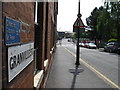
1
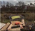
Birmingham
Abandoned development site off Granville Street.
Image: © Peter McDermott
Taken: 9 Jan 2015
0.01 miles
2
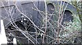
Tunnel to New Street, Granville Street
View from bridge across Granville Street of tunnel that takes cross-city rail services into New Street from south (Five Ways).
Image: © Michael Westley
Taken: 26 Dec 2009
0.02 miles
3
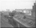
Site of Granville Street Station
Viewed from across wall on Communication Row, from bottom to top, left to right:
Archways (current cross-city route, north of Five Ways station)
Above archways, trackbed at location of Granville Street Station
Left-hand tunnel is road bridge (Granville Street), tunnel leading to Central Goods.
To right of trackbed, up embankment is a boarded up tunnel entrance (the original line stopped here, being prevented from going beyond the canal)
Beyond brick wall, Worcester & Birmingham canal
Beyond canal to right of photo, would be rear of Birmingham Accident Hospital (now moved)
http://www.railaroundbirmingham.co.uk/Stations/granville_street.php
See also Image] and Image]
Image: © Michael Westley
Taken: Unknown
0.03 miles
4
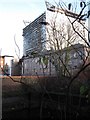
The Cube, Birmingham
View from Granville Street of latest addition to buildings in Birmingham. The Cube will be mixed residential and commercial accommodation. At bottom of photo can be seen roof of railway tunnel into New Street.
Image: © Michael Westley
Taken: 26 Dec 2009
0.03 miles
6
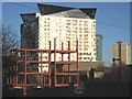
Work in progress, Holliday Street
Girder outline of new buildings, between Communication Street and Granville Street - 'The Cube' stands majestically a little beyond.
Image: © Michael Westley
Taken: 8 Jan 2011
0.04 miles
7
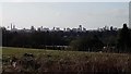
Birmingham Skyline
Birmingham Skyline from Sandwell Valley Hilltop
Image: © Frank Bruce
Taken: 29 Mar 2020
0.04 miles
8
Worcester and Birmingham Canal - Granville St Bridge
Image: © N Chadwick
Taken: 10 Jun 2011
0.04 miles
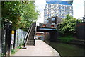
9
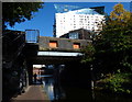
Granville Street Bridge No 88
The bridge is crossing the Worcester and Birmingham Canal.
The building is the Cube, the sixteenth tallest building in Birmingham, it is a 25 storey mixed-use development in the centre of Birmingham, part of the Mailbox development. It was completed in 2010 and is 70.4 m (231 ft) high.
Image: © Mat Fascione
Taken: 27 Sep 2015
0.04 miles
10
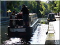
Narrowboat on the Worcester and Birmingham Canal
Image: © Mat Fascione
Taken: 27 Sep 2015
0.04 miles