IMAGES TAKEN NEAR TO
Roe End Lane, ST. ALBANS, AL3 8AH
Introduction
This page details the photographs taken nearby to Roe End Lane, AL3 8AH by members of the Geograph project.
The Geograph project started in 2005 with the aim of publishing, organising and preserving representative images for every square kilometre of Great Britain, Ireland and the Isle of Man.

There are currently over 7.5m images from over14,400 individuals and you can help contribute to the project by visiting https://www.geograph.org.uk
Image Map
Images are licensed for reuse under creativecommons.org/licenses/by-sa/2.0
Notes
- Clicking on the map will re-center to the selected point.
- The higher the marker number, the further away the image location is from the centre of the postcode.
Image Listing (5 Images Found)
Images are licensed for reuse under creativecommons.org/licenses/by-sa/2.0
Image
Details
Distance
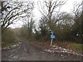
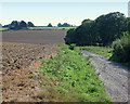
3
Verge on Roe End Lane
According to the maps this is a short cut from Cheverells Green to Studham. It isn't, it turns into a path just beyond this point. But it got me a map square which was what I was doing primarily.
Image: © David Howard
Taken: 11 Feb 2017
0.15 miles
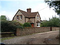
5
Track leading to Beechwood Farm
Beechwood Farm offers B and B and is accessed via this track which forms part of a Hertfordshire marked footpath. It must be a very remote but peaceful location.
Image: © Richard Thomas
Taken: 21 Sep 2006
0.21 miles