1
Upper Culver Road
Housing in the mainly late 19th/early 20th Century development of "Sandridge New Town", an area of land between Sandpit Lane and Sandridge Road, originally outside the boundaries of St Albans and in the parish of Sandridge, prior to the extension of the municipal area in 1879, just south of where Boundary Road was laid out. Upper Culver Road is the extension of Culver Road north of Boundary Road.
Image: © Ian Capper
Taken: 11 Sep 2020
0.01 miles
2
Upper Culver Road
Housing in the mainly late 19th/early 20th Century development of "Sandridge New Town", an area of land between Sandpit Lane and Sandridge Road, originally outside the boundaries of St Albans and in the parish of Sandridge, prior to the extension of the municipal area in 1879, just south of where Boundary Road was laid out.
Image: © Ian Capper
Taken: 5 Jul 2021
0.02 miles
3
Sandridge Road
Late 19th century/early 20th century terraced cottages in this part of St Albans originally called Sandridge New Town. Locally listed.
Image: © Ian Capper
Taken: 25 Jul 2012
0.04 miles
4
Sandridge Road
Late 19th century/early 20th century terraced cottages in this part of St Albans originally called Sandridge New Town (more specifically, the cottages on the left date from 1905). Locally listed.
Image: © Ian Capper
Taken: 25 Jul 2012
0.04 miles
5
Houses on Sandridge Road, Bernards Heath
Image: © David Howard
Taken: 22 Jul 2014
0.04 miles
6
Houses on Sandridge Road, Bernards Heath
Image: © David Howard
Taken: 22 Jul 2014
0.04 miles
7
Sandridge Road, Bernards Heath
Image: © David Howard
Taken: 22 Jul 2014
0.05 miles
8
New housing on Boundary Road
This was the site of a Primitive Methodist Church until 1987.
Image: © Bill Boaden
Taken: 29 Feb 2020
0.05 miles
9
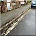
Channel, Upper Heath Road, St Albans
The three rows of stone blocks or setts forming the channel make a pleasing contrast with the tarmac: warm cream against purplish dark grey; coarse texture against fine-grained. The setts are the colour of Clunch but it seems unlikely that a form of chalk would be able to withstand wetting and the passage of vehicles.
Page 23 of the glorious Hertfordshire Strategic Stone Study from Historic England https://www2.bgs.ac.uk/mineralsuk/download/EHCountyAtlases/Hertfordshire_Building_Stone_Atlas.pdf illustrates a similar construction in St Michael's Street, St Albans. Upper Heath Road is unlikely to be different. The kerb (which could be mistaken for concrete) is identified as Sarsen Stone, probably from Buckinghamshire, and the setts as Granodiorite, an igneous rock well able to withstand wear and tear, possibly from the Newry area of County Armagh; 'Newry Granite', according to Wikipedia.
Image: © Robin Stott
Taken: 15 Nov 2022
0.05 miles
10
Upper Field, Bernards Heath
Lying alongside Sandridge Road, this area of common land is a popular recreation area. In the past it was used for playing cricket, being the site of the first playing of the game in St Albans in 1828 and for a time it served as the County cricket ground.
Image: © Ian Capper
Taken: 25 Jul 2012
0.05 miles


