Channel, Upper Heath Road, St Albans
Introduction
The photograph on this page of Channel, Upper Heath Road, St Albans by Robin Stott as part of the Geograph project.
The Geograph project started in 2005 with the aim of publishing, organising and preserving representative images for every square kilometre of Great Britain, Ireland and the Isle of Man.

There are currently over 7.5m images from over 14,400 individuals and you can help contribute to the project by visiting https://www.geograph.org.uk
Channel, Upper Heath Road, St Albans
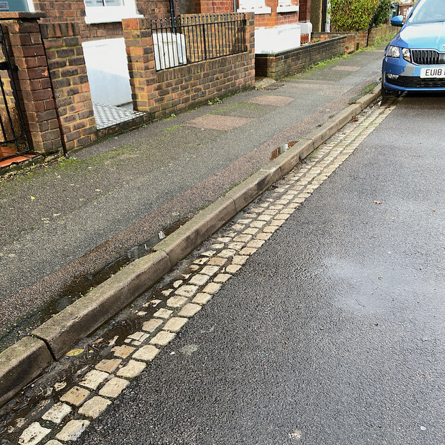
Image: © Robin Stott Taken: 15 Nov 2022
The three rows of stone blocks or setts forming the channel make a pleasing contrast with the tarmac: warm cream against purplish dark grey; coarse texture against fine-grained. The setts are the colour of Clunch but it seems unlikely that a form of chalk would be able to withstand wetting and the passage of vehicles. Page 23 of the glorious Hertfordshire Strategic Stone Study from Historic England https://www2.bgs.ac.uk/mineralsuk/download/EHCountyAtlases/Hertfordshire_Building_Stone_Atlas.pdf illustrates a similar construction in St Michael's Street, St Albans. Upper Heath Road is unlikely to be different. The kerb (which could be mistaken for concrete) is identified as Sarsen Stone, probably from Buckinghamshire, and the setts as Granodiorite, an igneous rock well able to withstand wear and tear, possibly from the Newry area of County Armagh; 'Newry Granite', according to Wikipedia.
Images are licensed for reuse under creativecommons.org/licenses/by-sa/2.0
Image Location
Latitude
51.760211
Longitude
-0.327019