IMAGES TAKEN NEAR TO
Upper Marlborough Road, ST. ALBANS, AL1 3UU
Introduction
This page details the photographs taken nearby to Upper Marlborough Road, AL1 3UU by members of the Geograph project.
The Geograph project started in 2005 with the aim of publishing, organising and preserving representative images for every square kilometre of Great Britain, Ireland and the Isle of Man.

There are currently over 7.5m images from over14,400 individuals and you can help contribute to the project by visiting https://www.geograph.org.uk
Image Map
Images are licensed for reuse under creativecommons.org/licenses/by-sa/2.0
Notes
- Clicking on the map will re-center to the selected point.
- The higher the marker number, the further away the image location is from the centre of the postcode.
Image Listing (335 Images Found)
Images are licensed for reuse under creativecommons.org/licenses/by-sa/2.0
Image
Details
Distance
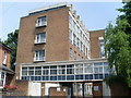
1
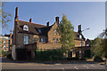
32-34 Upper Marlborough Road
A large Victorian house, now converted to offices. It is the only such survivor of the original buildings in this area of the city centre, now being surrounded by more modern buildings, mainly in civic use, including the telephone exchange, visible in the background. As such, it is locally listed.
Image: © Ian Capper
Taken: 2 Oct 2011
0.00 miles
2
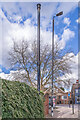
Sewer vent pipe
A Victorian sewer vent pipe in Upper Marlborough Street - see Image for a wider view.
Image: © Ian Capper
Taken: 14 Mar 2022
0.04 miles
3
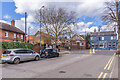
Upper Marlborough Road
The northern end of Upper Marlborough Road, as it approaches Hatfield Road, the road in the background. On the right is The Peacock (see Image). On the left is a sewer vent pipe - see Image for a close up.
Image: © Ian Capper
Taken: 14 Mar 2022
0.04 miles
4
Marlborough Buildings
The central part of the façade with the Marlborough coat of arms in the pediment. The façade was rebuilt in 1850 onto the original 1736 building. Listed Grade II.
Image: © Alan Murray-Rust
Taken: 2 Nov 2015
0.05 miles
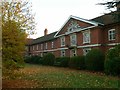
5
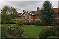
Marlborough Buildings
Built by Sarah, Duchess of Marlborough, in 1736, who was born in St Albans and whose family were major landowners there. They consist of a central block (seen here) including a bay topped by a pediment bearing the Marlborough arms. At either end of this block are two similar wings, with the whole set of buildings enclosing a mainly grass courtyard. There are 36 flats in all, in nine blocks of four.
Grade II listed - for listing particulars see www.historicengland.org.uk/listing/the-list/list-entry/1173192.
Image: © Ian Capper
Taken: 4 Oct 2011
0.05 miles
6
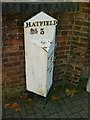
Milepost on Hatfield Road
Comprehensively described by Ian Capper here http://www.geograph.org.uk/photo/2705980 .
This view shows the other side of the post, which is, unusually, void of any lettering. Traditionally this would have referred to the next place to the right of the post, but this has already been incorporated into the top panel, and there are no other intermediate places of any consequence. Listed Grade II.
Image: © Alan Murray-Rust
Taken: 2 Nov 2015
0.05 miles
7
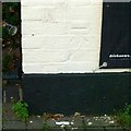
Bench Mark on The Peacock
See http://www.geograph.org.uk/photo/4745574 for location.
Image: © Alan Murray-Rust
Taken: 2 Nov 2015
0.05 miles
8
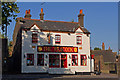
The Peacock
A locally listed pub on Hatfield Road. In a couple of years between 2007 and 2009 it went through various name changes: O'Neills, Ryans then back to O'Neills. It has now reverted to its original name, The Peacock. A 1634 map shows an Inn called The Peacock on the site, although the current building is clearly more recent, dating from the late 19th/early 20th century.
Image: © Ian Capper
Taken: 2 Oct 2011
0.05 miles
9
St Albans Telephone Exchange
Dating from 1958, it is situated at the end of Liverpool Road and replaced the former Manual TE. Its postcode is AL1 3UL.
Image: © David Hillas
Taken: 23 May 2009
0.05 miles
10
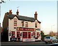
The Peacock, Hatfield Road
Public house on Hatfield Road.
There is a bench mark http://www.geograph.org.uk/photo/4745571 on the bottom left corner.
Image: © Alan Murray-Rust
Taken: 2 Nov 2015
0.05 miles