IMAGES TAKEN NEAR TO
Hatfield Road, ST. ALBANS, AL1 3RP
Introduction
This page details the photographs taken nearby to Hatfield Road, AL1 3RP by members of the Geograph project.
The Geograph project started in 2005 with the aim of publishing, organising and preserving representative images for every square kilometre of Great Britain, Ireland and the Isle of Man.

There are currently over 7.5m images from over14,400 individuals and you can help contribute to the project by visiting https://www.geograph.org.uk
Image Map
Images are licensed for reuse under creativecommons.org/licenses/by-sa/2.0
Notes
- Clicking on the map will re-center to the selected point.
- The higher the marker number, the further away the image location is from the centre of the postcode.
Image Listing (349 Images Found)
Images are licensed for reuse under creativecommons.org/licenses/by-sa/2.0
Image
Details
Distance
1
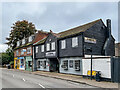
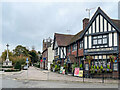
2 - 14 Hatfield Road
Row of shops and a restaurant in Hatfield Road.
Image: © Ian Capper
Taken: 4 Nov 2021
0.01 miles
2
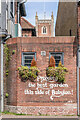
Wall, Blacksmith's Arms
Wall with a couple of hanging baskets in Hatfield Road next to the Blacksmith's Arms, with the wording "Probably the best garden this side of Babylon!", written in the style of a tagline of a well-known lager. See Image for a wider view. In the background is the tower of St Peter's Church.
Image: © Ian Capper
Taken: 15 Mar 2022
0.02 miles
3
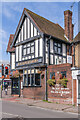
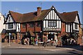
Blacksmith's Arms
Pub at the corner of Hatfield Road and St Peter's Street, built in 1929. On the right is the wall in Image
Image: © Ian Capper
Taken: 15 Mar 2022
0.02 miles
4
Blacksmith's Arms
Pub at the corner of Hatfield Road and St Peter's Street, built in 1929. On the right is the wall in Image
Image: © Ian Capper
Taken: 15 Mar 2022
0.02 miles
5
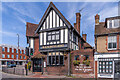
Blacksmiths Arms
Although older in appearance, this pub is a 20th century building dating from 1929, replacing a range of cottages on the site.
Image: © Ian Capper
Taken: 2 Oct 2011
0.03 miles
6
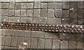
Channel cover, St Albans
Of cast iron, it bears the maker's name: J TOMKINS & SONS BUILDERS LUTON.
Image: © Robin Stott
Taken: 6 Apr 2023
0.03 miles
7
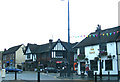
The Cock & Blacksmiths Arms Public Houses
On the A1081 Saint Peter's Street at the junction with the A1057 Hatfield Road
Image: © Geographer
Taken: 3 Jul 2012
0.03 miles
8
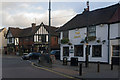
The Cock
A pub with 16th/early 17th century origins at the junction of Hatfield Road (formerly called Cock Lane) and St Peters Street. Grade II listed - for listing particulars see www.historicengland.org.uk/listing/the-list/list-entry/1251280.
Beyond, on the other side of Hatfield Road, is the Blacksmiths Arms - Image
Image: © Ian Capper
Taken: 3 Dec 2011
0.03 miles
9
Blacksmith's Arms
Pub at the corner of Hatfield Road and St Peter's Street, built in 1929. On the far left is the war memorial on Church Green (see Image) with the tower of St Peter's Church in the background.
Image: © Ian Capper
Taken: 4 Nov 2021
0.03 miles
10
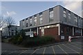
Former University of Hertfordshire St Albans Campus
Originally the St Albans College of Art, it late became part of the University of Hertfordshire, housing its School of Law and the Margaret Harvey Gallery until 2010.
Image: © Ian Capper
Taken: 3 Dec 2011
0.03 miles