IMAGES TAKEN NEAR TO
Bedford Road, ST. ALBANS, AL1 3BQ
Introduction
This page details the photographs taken nearby to Bedford Road, AL1 3BQ by members of the Geograph project.
The Geograph project started in 2005 with the aim of publishing, organising and preserving representative images for every square kilometre of Great Britain, Ireland and the Isle of Man.

There are currently over 7.5m images from over14,400 individuals and you can help contribute to the project by visiting https://www.geograph.org.uk
Image Map
Images are licensed for reuse under creativecommons.org/licenses/by-sa/2.0
Notes
- Clicking on the map will re-center to the selected point.
- The higher the marker number, the further away the image location is from the centre of the postcode.
Image Listing (261 Images Found)
Images are licensed for reuse under creativecommons.org/licenses/by-sa/2.0
Image
Details
Distance
1
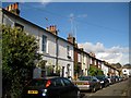
St Albans: Alexandra Road
Alexandra Road contains these Victorian terraced houses on a thoroughfare that used to link Lattimore Road with Alma Road, but now blocked to vehicular traffic.
Image: © Nigel Cox
Taken: 6 Jul 2009
0.02 miles
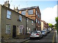
2
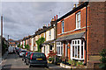
Alexandra Road
Victorian terraced cottages on a road off Alma Road, built around 1860. Locally listed.
Image: © Ian Capper
Taken: 4 Oct 2011
0.04 miles
4
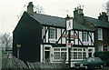
The Robin Hood
This Whitbread house on Victoria Street is now a free house. The pub sign has been repainted and trestle tables have replaced the car on the pavement. The adjacent derelict land has been built on since this photo was taken.
Image: © Martin Addison
Taken: Unknown
0.05 miles
5
St Albans: Inkerman Road and a former hat factory
Just like nearby Image Inkerman Road was named by the Victorians to celebrate a victory in the Crimean War. The Battle of Inkerman was fought on 5 November 1854 and resulted in success for an Anglo-French force under Lord Raglan's command who defeated a Russian army. Inkerman does not seem to have been regarded as popular as Alma though by the street-naming fraternity and StreetMap throws up just 8 other Inkerman Roads in the country.
However the hat factory predates all this having been built around 1825, and the photograph illustrates how industry and homes must have existed cheek by jowl in those days.
But modern controversy gives two twists to the story of Inkerman Road. Firstly the hat factory was the last surviving one in St Albans and when it came up for sale in 2006 the local arts group wanted to buy it as a studio, it being eminently suitable for their needs with its large windows giving lots of natural light. Despite alleged requests from the local arts group to give them time to raise the necessary funds, the local council reputedly sold the property to a private developer who converted it into flats.
Secondly various properties on the right side of the road, unseen in the photo, have been bought through the years by Tesco who have plans to use a large former industrial site nearby on London Road for a supermarket. Those plans appear to be currently stalled and the boarded up houses have now been squatted, much to the concern of the local permanent residents.
Image: © Nigel Cox
Taken: 6 Jul 2009
0.05 miles
6
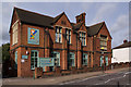
Playschool House
Former infants school ("St Albans School-Board Public Elementary School) built in 1882 and extended in 1890. Recently reopened as a nursery school. Locally listed.
Image: © Ian Capper
Taken: 4 Oct 2011
0.06 miles
7
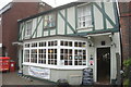
The Robin Hood public house
On Victoria Street, St Albans.
Image: © Ian S
Taken: 18 Jun 2022
0.06 miles
8
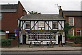
The Robin Hood
A Victorian pub hidden between an Iceland supermarket and some terraced cottages.
Image: © Ian Capper
Taken: 4 Oct 2011
0.06 miles
9
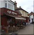
Cafe Alfresco, Victoria Street
Next door is the Victoria pub
Image: © Robert Eva
Taken: 6 May 2017
0.06 miles
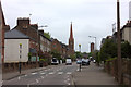
10
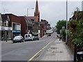
Victoria Street St Albans
looking towards Trinity United Reformed Church
Image: © HENRY CLARK
Taken: 30 May 2008
0.07 miles