St Albans: Inkerman Road and a former hat factory
Introduction
The photograph on this page of St Albans: Inkerman Road and a former hat factory by Nigel Cox as part of the Geograph project.
The Geograph project started in 2005 with the aim of publishing, organising and preserving representative images for every square kilometre of Great Britain, Ireland and the Isle of Man.

There are currently over 7.5m images from over 14,400 individuals and you can help contribute to the project by visiting https://www.geograph.org.uk
St Albans: Inkerman Road and a former hat factory
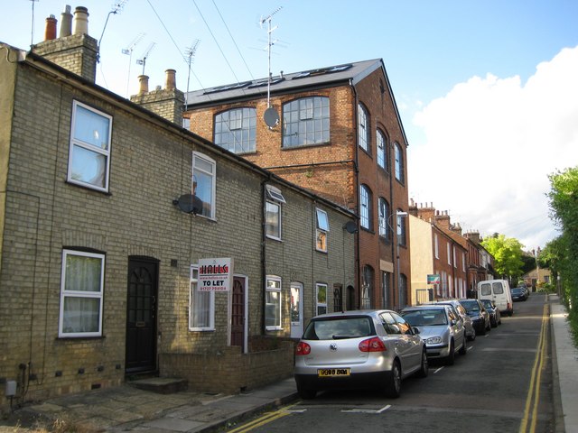
Image: © Nigel Cox Taken: 6 Jul 2009
Just like nearby Image Inkerman Road was named by the Victorians to celebrate a victory in the Crimean War. The Battle of Inkerman was fought on 5 November 1854 and resulted in success for an Anglo-French force under Lord Raglan's command who defeated a Russian army. Inkerman does not seem to have been regarded as popular as Alma though by the street-naming fraternity and StreetMap throws up just 8 other Inkerman Roads in the country. However the hat factory predates all this having been built around 1825, and the photograph illustrates how industry and homes must have existed cheek by jowl in those days. But modern controversy gives two twists to the story of Inkerman Road. Firstly the hat factory was the last surviving one in St Albans and when it came up for sale in 2006 the local arts group wanted to buy it as a studio, it being eminently suitable for their needs with its large windows giving lots of natural light. Despite alleged requests from the local arts group to give them time to raise the necessary funds, the local council reputedly sold the property to a private developer who converted it into flats. Secondly various properties on the right side of the road, unseen in the photo, have been bought through the years by Tesco who have plans to use a large former industrial site nearby on London Road for a supermarket. Those plans appear to be currently stalled and the boarded up houses have now been squatted, much to the concern of the local permanent residents.
Images are licensed for reuse under creativecommons.org/licenses/by-sa/2.0
Image Location
Latitude
51.749409
Longitude
-0.332489