IMAGES TAKEN NEAR TO
Trumpington Drive, ST. ALBANS, AL1 2JY
Introduction
This page details the photographs taken nearby to Trumpington Drive, AL1 2JY by members of the Geograph project.
The Geograph project started in 2005 with the aim of publishing, organising and preserving representative images for every square kilometre of Great Britain, Ireland and the Isle of Man.

There are currently over 7.5m images from over14,400 individuals and you can help contribute to the project by visiting https://www.geograph.org.uk
Image Map
Images are licensed for reuse under creativecommons.org/licenses/by-sa/2.0
Notes
- Clicking on the map will re-center to the selected point.
- The higher the marker number, the further away the image location is from the centre of the postcode.
Image Listing (29 Images Found)
Images are licensed for reuse under creativecommons.org/licenses/by-sa/2.0
Image
Details
Distance
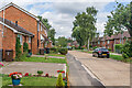
2
Path onto Abbots Avenue West
The path has come from Tavistock Avenue on an adjoining estate. It is viewed on a dull wet day.
Image: © Bill Boaden
Taken: 28 Feb 2020
0.07 miles
3
Wallingford Walk
Viewed from Abbots Avenue West. A residential part of St Julians.
Image: © Bill Boaden
Taken: 28 Feb 2020
0.09 miles
4
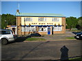
St Albans: The King Offa
Just what King Offa would have thought of the fact that a neighbourhood pub in Wallingford Walk on the Cottonmill estate was named after him will unfortunately have to remain a matter of conjecture. That said he did found St Albans Abbey in the 790s shortly before his death in 796.
Image: © Nigel Cox
Taken: 11 May 2009
0.11 miles
5
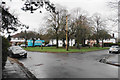
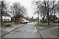
Green circle on Tavistock Avenue
A green enclave in the centre of the estate.
Image: © Bill Boaden
Taken: 28 Feb 2020
0.13 miles
6
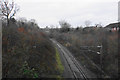
Railway to St Albans
The line leads to Abbey Station. The cathedral can be seen in the distance.
Image: © Bill Boaden
Taken: 28 Feb 2020
0.14 miles
7
Abbots Avenue
Looking along Abbots Avenue, with the bridge carrying the road over the Watford Junction to St Albans Abbey "Abbey Line" in the centre of the photo.
Image: © Ian Capper
Taken: 5 Aug 2021
0.16 miles
8

St Albans: The Abbey Flyer line
Viewed from the Abbotts Avenue bridge about a kilometre south of the St Albans Abbey terminus, the railway was built in 1858 by the London & North Western Railway and was the first line to be constructed into St Albans.
Image: © Nigel Cox
Taken: 11 May 2009
0.16 miles
9
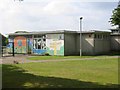
Mandeville Junior and Infants School in St Julians district
Prefab construction doesn't weather too well and so needs more loving care.
Image: © Jack Hill
Taken: 15 Aug 2005
0.16 miles
10
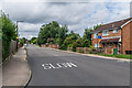
Berners Drive
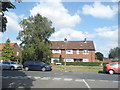
Road developed in the c.1950s along with the rest of the area off Cottomnill Lane. The houses on the right would appear to be original, but although the area on the left is shown on the 1960 1:10,000 map as having also been built up, with individual detached houses set diagonally to the road, the ones here would appear to be a substituent redevelopment, dating from the late 1970s according to planning documents.
The tower of St Albans Abbey can be seen in the background.
Image: © Ian Capper
Taken: 5 Aug 2021
0.17 miles