IMAGES TAKEN NEAR TO
Cottonmill Lane, ST. ALBANS, AL1 2ET
Introduction
This page details the photographs taken nearby to Cottonmill Lane, AL1 2ET by members of the Geograph project.
The Geograph project started in 2005 with the aim of publishing, organising and preserving representative images for every square kilometre of Great Britain, Ireland and the Isle of Man.

There are currently over 7.5m images from over14,400 individuals and you can help contribute to the project by visiting https://www.geograph.org.uk
Image Map
Images are licensed for reuse under creativecommons.org/licenses/by-sa/2.0
Notes
- Clicking on the map will re-center to the selected point.
- The higher the marker number, the further away the image location is from the centre of the postcode.
Image Listing (36 Images Found)
Images are licensed for reuse under creativecommons.org/licenses/by-sa/2.0
Image
Details
Distance
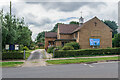
1
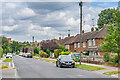
Cottonmill Lane
c.1950s housing in Cottonmill Lane. Although not developed until then, the route itself is much older, being the route from St Albans out to Sopwell from St Albans. In the left background the tower of St Albans Abbey can be seen.
Image: © Ian Capper
Taken: 5 Aug 2021
0.03 miles
2
St Albans: Christadelphian Hall
The hall is in Abbotts Avenue opposite Image and its foundation stone was laid in 1952. For further information on the Christadelphian movement please see their website here http://www.godsaves.co.uk/index.htm
Image: © Nigel Cox
Taken: 11 May 2009
0.04 miles
3
St Albans Christadelphians
Church in Abbots Avenue built in the early 1950s as Cottonmill Baptist Church It closed in 1968 when the church merged with Park Street Baptist Church, but was taken over by the Christadelphians in 1976.
Image: © Ian Capper
Taken: 5 Aug 2021
0.05 miles
4
Masjid Ar Rahman, Abbots Avenue
Previously pictured as a Christadelphian Church Image this is now a masjid (mosque).
Image: © Des Blenkinsopp
Taken: 25 Aug 2024
0.05 miles
5
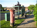
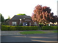
St Albans: Abbotts Avenue
Amongst the motley collection of street furniture on view here the postbox seems to be suffering from advanced psoriasis, Royal Mail Engineering please take note!
As ever "Abbotts" Avenue will generate complaints that it should be "Abbots". Indeed a Google search for "St Albans" and "Abbotts Avenue" currently gets 102 hits while the same combo with "Abbots" gets 844, and the Royal Mail, the Ordnance Survey and Streetmap all have Abbots. However the street name plate on the road has "Abbotts" so "Abbotts" it is!
Image: © Nigel Cox
Taken: 11 May 2009
0.06 miles
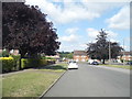
6
Berners Drive
Road developed in the c.1950s along with the rest of the area off Cottomnill Lane. The houses on the right would appear to be original, but although the area on the left is shown on the 1960 1:10,000 map as having also been built up, with individual detached houses set diagonally to the road, the ones here would appear to be a substituent redevelopment, dating from the late 1970s according to planning documents.
The tower of St Albans Abbey can be seen in the background.
Image: © Ian Capper
Taken: 5 Aug 2021
0.06 miles
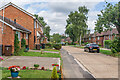
7
Abbots Avenue at the junction of Cottonmill Lane
Image: © David Howard
Taken: 22 Jul 2014
0.07 miles
8
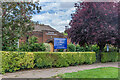
St Albans: Church of St Julian
The church was built to serve the Cottonmill Lane housing estate and its foundation stone was laid in 1956. The church is in Abbotts Avenue. The crosses in the gable end walls are actually made out of slightly darker bricks with air gaps between them.
Image: © Nigel Cox
Taken: 11 May 2009
0.07 miles
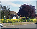
9
St Julian's Church
Church in Abbots Avenue opened in 1956, as a permanent building for a congregation founded in 1952 housed in a Nissen Hut as part of an anti aircraft searchlight emplacement.
Image: © Ian Capper
Taken: 5 Aug 2021
0.08 miles
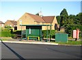
10
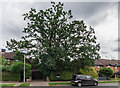
Old Oak, Cottonmill Lane
At first sight the street sign "Old Oak" might seem to refer to this tree. In fact it is the name of a small cul-de-sac built in c.1995 (see Image, the rear of some of whose houses are on the right in this photo.
Image: © Ian Capper
Taken: 5 Aug 2021
0.08 miles