IMAGES TAKEN NEAR TO
Prospect Road, ST. ALBANS, AL1 2AU
Introduction
This page details the photographs taken nearby to Prospect Road, AL1 2AU by members of the Geograph project.
The Geograph project started in 2005 with the aim of publishing, organising and preserving representative images for every square kilometre of Great Britain, Ireland and the Isle of Man.

There are currently over 7.5m images from over14,400 individuals and you can help contribute to the project by visiting https://www.geograph.org.uk
Image Map (Loading...)


Getting Data...Please wait
Leaflet Map data © OpenStreetMap
Images are licensed for reuse under creativecommons.org/licenses/by-sa/2.0
Notes
- Clicking on the map will re-center to the selected point.
- The higher the marker number, the further away the image location is from the centre of the postcode.
Image Listing (83 Images Found)
Images are licensed for reuse under creativecommons.org/licenses/by-sa/2.0
Image
Details
Distance
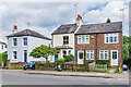
1
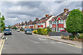
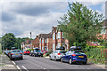
Prospect Road
Semi-detached houses at the Cottonmill Lane end of Prospect Road, built in 1928-30. Prospect Road started out as a cul-de-sac off Holywell Hill, first developed in the second half of the 19th Century. The eastward extension, as seen here, linked it through to Cottonmill Lane, along the route of a former footpath.
Image: © Ian Capper
Taken: 5 Aug 2021
0.03 miles
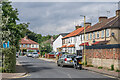
2
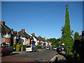
St Albans: Prospect Road
The houses at the eastern end of Prospect Road are mainly bay-fronted between-the-wars semis, but the totally vegetation-clad telegraph pole with its massed ranks of radiating cables was something different!
Image: © Nigel Cox
Taken: 29 May 2009
0.04 miles
3
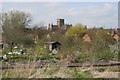
The Allotments
Near the River Ver are the Allotments just off Cottonmill Lane.
Image: © Martin Stewart
Taken: 10 Apr 2005
0.06 miles
4
Cottonmill Lane
c.1930s housing in Cottonmill Lane, by its junction with Prospect Road. Although not developed until then, the route itself is much older, being the route from St Albans out to Sopwell from St Albans.
Image: © Ian Capper
Taken: 5 Aug 2021
0.07 miles
5
St Julian's Road
Cul-de-sac off Prospect Road, ending at the Watford Junction - St Albans Abbey "Abbey Line". Originally laid out in 1912 with houses built on the eastern side, the western side, see here, was developed later, in the c.1930s.
Image: © Ian Capper
Taken: 5 Aug 2021
0.07 miles
6
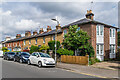
Prospect Road
Terraced cottages in Prospect Road, built c.1870. No 57, on the right, although of a different style, abuts the terrace and was built at the same time.
Image: © Ian Capper
Taken: 5 Aug 2021
0.08 miles
7
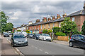
Prospect Road
Terraced cottages in Prospect Road, built c.1870.
Image: © Ian Capper
Taken: 5 Aug 2021
0.08 miles
8
Cottonmill Lane
c.1930s housing in Cottonmill Lane, on the section between Leyland Avenue and Prospect Road. Although not developed until then, the route itself is much older, being the route from St Albans out to Sopwell from St Albans.
Image: © Ian Capper
Taken: 5 Aug 2021
0.09 miles
9
Leyland Avenue
c.1930s housing in Leyland Avenue, a cul-de-sac off Cottonmill Lane.
Image: © Ian Capper
Taken: 5 Aug 2021
0.10 miles
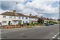
10
Prospect Road
Victorian cottages in Prospect Road, built c.1870.
No 25, on the left, was for a time the home of the builder William Longmire, who was responsible for much of the restoration work carried out on St Albans Abbey in the 1870s/80s, firstly under the supervision of Sir Giles Gilbert Scott and then Edmund Beckett (later Lord Grimthorpe). He was also involved in the building of Batchwood Hall for Lord Grimthorpe, also in the 1870s. Another of his works was to extend the chapel at Lincoln's Inn in London in the 1880s, with the architect again being Lord Grimthorpe. Part of this involved the removal of a 15 foot high arch, which he reconstructed in the rear garden of no 25 where it still stands (see Image). The house was originally named Ousby Cottage, Ousby near Penrith being where Longmire was born in 1825.
Image: © Ian Capper
Taken: 5 Aug 2021
0.10 miles