IMAGES TAKEN NEAR TO
Roberts Way, HATFIELD, AL10 9UY
Introduction
This page details the photographs taken nearby to Roberts Way, AL10 9UY by members of the Geograph project.
The Geograph project started in 2005 with the aim of publishing, organising and preserving representative images for every square kilometre of Great Britain, Ireland and the Isle of Man.

There are currently over 7.5m images from over14,400 individuals and you can help contribute to the project by visiting https://www.geograph.org.uk
Image Map
Images are licensed for reuse under creativecommons.org/licenses/by-sa/2.0
Notes
- Clicking on the map will re-center to the selected point.
- The higher the marker number, the further away the image location is from the centre of the postcode.
Image Listing (7 Images Found)
Images are licensed for reuse under creativecommons.org/licenses/by-sa/2.0
Image
Details
Distance
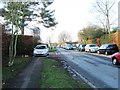
2
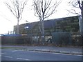
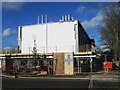
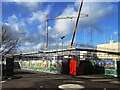
Green clad building, University of Hertfordshire
This is clad with the same panels as the North Circular Road in Golders Green. The plants are watered by the rain and insulate the building.
Image: © David Howard
Taken: 25 Nov 2017
0.07 miles
5
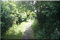
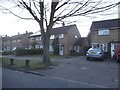
Path off Bishops Rise, Hatfield
Towards Roe Hill Park.
Image: © Ian S
Taken: 19 Jun 2022
0.22 miles
7
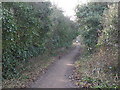
Alban Way. Old Nast Hyde Halt Station. Hatfield.
Alban Way is a cycle and footpath which runs along the route of the old Hatfield to St Albans railway.
The platform was the old Station, Nast Hyde Halt. It was opened in 1910 and closed in 1951. Photographed looking west from Ellenbrook Lane.
Image: © Barry Lawson
Taken: 24 Jan 2006
0.24 miles