IMAGES TAKEN NEAR TO
Ellenbrook Lane, HATFIELD, AL10 9NY
Introduction
This page details the photographs taken nearby to Ellenbrook Lane, AL10 9NY by members of the Geograph project.
The Geograph project started in 2005 with the aim of publishing, organising and preserving representative images for every square kilometre of Great Britain, Ireland and the Isle of Man.

There are currently over 7.5m images from over14,400 individuals and you can help contribute to the project by visiting https://www.geograph.org.uk
Image Map
Images are licensed for reuse under creativecommons.org/licenses/by-sa/2.0
Notes
- Clicking on the map will re-center to the selected point.
- The higher the marker number, the further away the image location is from the centre of the postcode.
Image Listing (35 Images Found)
Images are licensed for reuse under creativecommons.org/licenses/by-sa/2.0
Image
Details
Distance
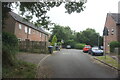
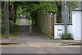
2
Comet Way, Hatfield
Alongside the A1(M). The little hut is for the aerials just out of sight.
Image: © David Howard
Taken: 25 Nov 2017
0.11 miles
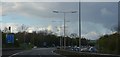
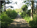
3
Ellenbrooke Lane crossing looking south west
A lot of restoration work has been done here since photo 111451 taken 11 years ago.
Image: © Robert Eva
Taken: 6 May 2017
0.11 miles
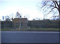
5
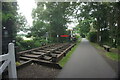
Hatfield: Site of the former Nast Hyde Halt
The Hatfield & St Albans Railway opened their line through here, linking the two towns, in 1865. The railway was subsequently absorbed into the Great Northern Railway in 1883, but Nast Hyde Halt was not built until 1910. Passenger services on the railway were an early casualty of the pre-Beeching era of British Railways, closing just 3 years into Nationalization in 1951, with the halt obviously closing at the same time. Freight traffic on the line lingered into the 1960s, and the track was still in use in 1967 as evidenced by Nick Catford's photograph from a similar viewpoint here http://www.disused-stations.org.uk/n/nast_hyde_halt/index1.shtml
Today the route of the railway forms the Alban Way, or the Smallford Trail, and a section of National Cycle Network Route 61.
Image: © Nigel Cox
Taken: 19 Apr 2011
0.12 miles
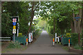
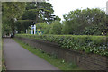
6
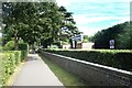
Alban Way crosses Ellenbrook Lane
It looks like a genuine old level crossing sign on the wall to the right.
Image: © Robert Eva
Taken: 6 May 2017
0.12 miles
7
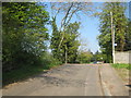
Ellenbrook: Site of the former Ellenbrook Lane level crossing
This is the point at which the former Hatfield & St Albans Railway crossed Ellenbrook Lane. Nast Hyde Halt was to the left. The railway was in use until the 1960s.
Image: © Nigel Cox
Taken: 19 Apr 2011
0.12 miles
9
Nast Hyde Halt
An early casualty of station closures which saw its last passengers way back in 1951.
Derelict for many years, it has since been transformed from this Image into what you see here.
A key figure in the restoration is a local enthusiast Mike the Stationmaster who I met serving tea & coffee here on a summer Sunday afternoon. The old track is now the Alban Way and is well used by walkers, joggers, cyclists, dogs and all the rest.
Image: © Des Blenkinsopp
Taken: 25 Aug 2024
0.12 miles