IMAGES TAKEN NEAR TO
Orchid Close, HATFIELD, AL10 9FE
Introduction
This page details the photographs taken nearby to Orchid Close, AL10 9FE by members of the Geograph project.
The Geograph project started in 2005 with the aim of publishing, organising and preserving representative images for every square kilometre of Great Britain, Ireland and the Isle of Man.

There are currently over 7.5m images from over14,400 individuals and you can help contribute to the project by visiting https://www.geograph.org.uk
Image Map
Images are licensed for reuse under creativecommons.org/licenses/by-sa/2.0
Notes
- Clicking on the map will re-center to the selected point.
- The higher the marker number, the further away the image location is from the centre of the postcode.
Image Listing (5 Images Found)
Images are licensed for reuse under creativecommons.org/licenses/by-sa/2.0
Image
Details
Distance
1
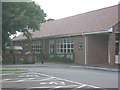
Green Lanes Primary School Hatfield
This school serves the area known as Hatfield Garden village which is physically separated from Hatfield by the A1001 and A1(M).
Image: © Jack Hill
Taken: 7 Aug 2005
0.07 miles
4
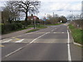
Green Lanes
Green Lanes by Great Braitch Lane
Image: © Shaun Ferguson
Taken: 28 Mar 2010
0.15 miles
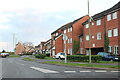
5
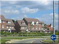
Housing at Hatfield Garden Village
Compared with the layouts of Welwyn Garden city this area is way below par. But then a generation separates the two
Image: © Jack Hill
Taken: 7 Aug 2005
0.24 miles