IMAGES TAKEN NEAR TO
Beaconsfield Close, HATFIELD, AL10 8YE
Introduction
This page details the photographs taken nearby to Beaconsfield Close, AL10 8YE by members of the Geograph project.
The Geograph project started in 2005 with the aim of publishing, organising and preserving representative images for every square kilometre of Great Britain, Ireland and the Isle of Man.

There are currently over 7.5m images from over14,400 individuals and you can help contribute to the project by visiting https://www.geograph.org.uk
Image Map
Images are licensed for reuse under creativecommons.org/licenses/by-sa/2.0
Notes
- Clicking on the map will re-center to the selected point.
- The higher the marker number, the further away the image location is from the centre of the postcode.
Image Listing (43 Images Found)
Images are licensed for reuse under creativecommons.org/licenses/by-sa/2.0
Image
Details
Distance
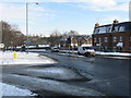
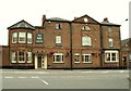
2
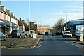
B6426 St Albans Road East, Hatfield
A surprising road name as it is heading east from the modern town centre towards Hertford, the opposite direction to St Albans.
Image: © Robin Webster
Taken: 17 Feb 2019
0.03 miles
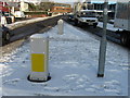
3
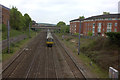
St Albans Road East bridge looking south
A Great Northern 365 set on its way north.
Image: © Robert Eva
Taken: 6 May 2017
0.04 miles
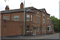
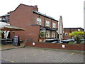
7
'The Red Lion' public house
This large public house stands along the A1000 on the Great North Road in Old Hatfield.
Image: © Robert Edwards
Taken: 3 Jun 2009
0.11 miles