IMAGES TAKEN NEAR TO
Finch Close, HATFIELD, AL10 8RH
Introduction
This page details the photographs taken nearby to Finch Close, AL10 8RH by members of the Geograph project.
The Geograph project started in 2005 with the aim of publishing, organising and preserving representative images for every square kilometre of Great Britain, Ireland and the Isle of Man.

There are currently over 7.5m images from over14,400 individuals and you can help contribute to the project by visiting https://www.geograph.org.uk
Image Map
Images are licensed for reuse under creativecommons.org/licenses/by-sa/2.0
Notes
- Clicking on the map will re-center to the selected point.
- The higher the marker number, the further away the image location is from the centre of the postcode.
Image Listing (11 Images Found)
Images are licensed for reuse under creativecommons.org/licenses/by-sa/2.0
Image
Details
Distance
3
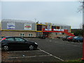
Hatfield Leisure Centre.
Marked as Oxlease Leisure Centre on the map but the sign on the front of the building refers to Hatfield LS.
Image: © Robin Hall
Taken: 23 Nov 2005
0.06 miles
4
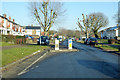
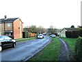
Traffic calming on Travellers Lane
One of a series of alternating hand.
Image: © Robin Webster
Taken: 17 Feb 2019
0.07 miles
7
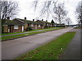
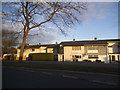
South Hatfield: The Downs
This is a view of the typical 1950s bungalows on the estate. The nearby estate roads are called The Cheviots, The Chilterns, and The Cotswolds.
Image: © Nigel Cox
Taken: 5 Jan 2007
0.20 miles
10
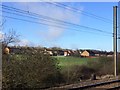
View from a Peterborough-London train - Playing field through the trees, South Hatfield
Image: © Nigel Thompson
Taken: 7 Feb 2017
0.24 miles