IMAGES TAKEN NEAR TO
Old French Horn Lane, HATFIELD, AL10 8AH
Introduction
This page details the photographs taken nearby to Old French Horn Lane, AL10 8AH by members of the Geograph project.
The Geograph project started in 2005 with the aim of publishing, organising and preserving representative images for every square kilometre of Great Britain, Ireland and the Isle of Man.

There are currently over 7.5m images from over14,400 individuals and you can help contribute to the project by visiting https://www.geograph.org.uk
Image Map
Images are licensed for reuse under creativecommons.org/licenses/by-sa/2.0
Notes
- Clicking on the map will re-center to the selected point.
- The higher the marker number, the further away the image location is from the centre of the postcode.
Image Listing (44 Images Found)
Images are licensed for reuse under creativecommons.org/licenses/by-sa/2.0
Image
Details
Distance
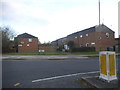
3
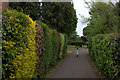
Recreation ground near Hatfield centre
Off Old French Horn Lane. This little recreation ground does not appear to have any name.
Image: © Robert Eva
Taken: 6 May 2017
0.06 miles
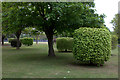
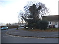
6
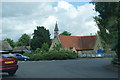
Roundabout by St Luke's Church, Hatfield
Image: © Bill Boaden
Taken: 1 Jul 2012
0.13 miles
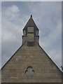
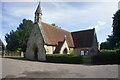
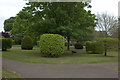
9
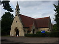
St Luke's Church, Hatfield
Dates from 1877, this church was originally the chapel for the adjoining cemetery
Image: © Jim Osley
Taken: 8 Aug 2010
0.15 miles
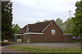
10
Link Drive at the junction of Old Rectory Drive
Image: © David Howard
Taken: 25 Nov 2017
0.15 miles