IMAGES TAKEN NEAR TO
Wellands, HATFIELD, AL10 0DB
Introduction
This page details the photographs taken nearby to Wellands, AL10 0DB by members of the Geograph project.
The Geograph project started in 2005 with the aim of publishing, organising and preserving representative images for every square kilometre of Great Britain, Ireland and the Isle of Man.

There are currently over 7.5m images from over14,400 individuals and you can help contribute to the project by visiting https://www.geograph.org.uk
Image Map
Images are licensed for reuse under creativecommons.org/licenses/by-sa/2.0
Notes
- Clicking on the map will re-center to the selected point.
- The higher the marker number, the further away the image location is from the centre of the postcode.
Image Listing (24 Images Found)
Images are licensed for reuse under creativecommons.org/licenses/by-sa/2.0
Image
Details
Distance
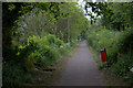
1
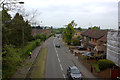
Wellfield Road, Birchwood
Taken from the Alban Way footbridge looking north.
Image: © Robert Eva
Taken: 6 May 2017
0.03 miles
2
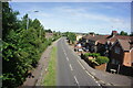
Westfield Road, Hatfield
Taken from the Alban Way footbridge.
Image: © Ian S
Taken: 19 Jun 2022
0.03 miles
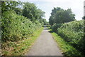
3
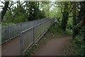
Alban Way footbridge over Wellfield Road/Wells Way
Image: © Robert Eva
Taken: 6 May 2017
0.06 miles
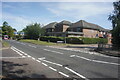
4
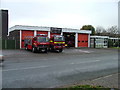
Hatfield Fire and Rescue Station.
Not busy today. may it stay that way.
Image: © Robin Hall
Taken: 23 Nov 2005
0.11 miles
7
Birchwood Avenuce Shops Looking South, Hatfield
Image: © Chris Reynolds
Taken: 23 Apr 2009
0.13 miles
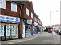
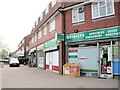
9
Hatfield: Birchwood Avenue shops
The shops are on the south-east side of the roundabout at the junction of Birchwood Avenue with Crawford Road and Chelwood Avenue.
Image: © Nigel Cox
Taken: 2 Jul 2008
0.14 miles
10
Birchwood Avenue Shops Looking East, Hatfield
Image: © Chris Reynolds
Taken: 23 Apr 2009
0.15 miles