IMAGES TAKEN NEAR TO
Auchterless, TURRIFF, AB53 8AY
Introduction
This page details the photographs taken nearby to AB53 8AY by members of the Geograph project.
The Geograph project started in 2005 with the aim of publishing, organising and preserving representative images for every square kilometre of Great Britain, Ireland and the Isle of Man.

There are currently over 7.5m images from over14,400 individuals and you can help contribute to the project by visiting https://www.geograph.org.uk
Image Map
Images are licensed for reuse under creativecommons.org/licenses/by-sa/2.0
Notes
- Clicking on the map will re-center to the selected point.
- The higher the marker number, the further away the image location is from the centre of the postcode.
Image Listing (6 Images Found)
Images are licensed for reuse under creativecommons.org/licenses/by-sa/2.0
Image
Details
Distance
1
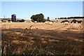
Hatton Manor
Straw bales by the farm buildings at Hatton Manor.
Image: © Anne Burgess
Taken: 21 Sep 2007
0.14 miles
2
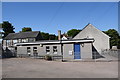
Auchterless primary school
The school roll (2017-18) is 25 taught in two classes with the catchment area covering many square kilometres of the sparsely populated surrounding countryside.
Image: © Bill Harrison
Taken: 26 May 2018
0.22 miles
3
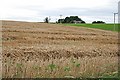
Croft of Balmuir
Balmuir Croft was also known as the 'Beadle's Croft' because traditionally the beadle lived here. It is not clear whether the tenant was obliged to act as beadle, or whether the tenancy was a perk of being the beadle. The croft was seven acres, and the house stood at the northern apex of its ground. The field boundaries are on the mid-Victorian six-inch Ordnance Survey map, but the fences have been taken out so they are not on the modern maps. The croft is part of Hatton Castle estate, but the house was sold to the Water Board in the 1960s. They demolished it and built a reservoir where the house used to be. The modern house in this view was built later in a corner of a field across the road. My thanks to Eric Stephen for information, and to Claire Jordan and Alison Jaffrey for putting me in touch.
Image: © Anne Burgess
Taken: 13 Sep 2007
0.22 miles
5
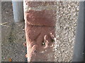
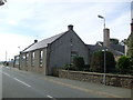
Ordnance Survey Cut Mark
This can be found on the wall of the school.
For more detail see : http://www.bench-marks.org.uk/bm45919
Image: © Peter Wood
Taken: 6 Oct 2012
0.24 miles
6
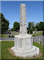
Auchterless war memorial
An unusual and dramatic broken column (or obelisk?).
Image: © Bill Harrison
Taken: 26 May 2018
0.25 miles