IMAGES TAKEN NEAR TO
TURRIFF, AB53 4NJ
Introduction
This page details the photographs taken nearby to AB53 4NJ by members of the Geograph project.
The Geograph project started in 2005 with the aim of publishing, organising and preserving representative images for every square kilometre of Great Britain, Ireland and the Isle of Man.

There are currently over 7.5m images from over14,400 individuals and you can help contribute to the project by visiting https://www.geograph.org.uk
Image Map
Images are licensed for reuse under creativecommons.org/licenses/by-sa/2.0
Notes
- Clicking on the map will re-center to the selected point.
- The higher the marker number, the further away the image location is from the centre of the postcode.
Image Listing (11 Images Found)
Images are licensed for reuse under creativecommons.org/licenses/by-sa/2.0
Image
Details
Distance
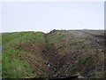
1
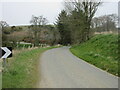
C2S (Aberdeenshire) Road near Lower Muirden
C2S road twisting northwards near Lower Muirden.
Image: © Scott Cormie
Taken: 16 Apr 2022
0.03 miles
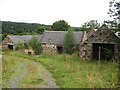
3
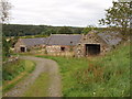
Farm buildings at Lower Muirden
The buildings are fenced off from the track to the farmhouse, and seem to be out of use and falling into disrepair.
Image: © David Hawgood
Taken: 13 Sep 2007
0.08 miles
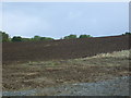
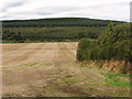
4
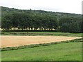
Wheat, Muirden
A field above the ruins of Lower Muirden.
Image: © Richard Webb
Taken: 5 Aug 2011
0.08 miles
6
Lower Muirden
The steading was derelict in 2007 and little had changed.
Image]
The name is Nether Muirden on older Ordnance Survey maps.
Image: © Richard Webb
Taken: 4 Aug 2011
0.09 miles
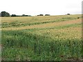
7
Hedge and field by Lower Muirden
The field runs down to the River Deveron. It has been harvested, and straw removed. The hedge is beside the Lower Muirden farm buildings.
Image: © David Hawgood
Taken: 13 Sep 2007
0.11 miles
8
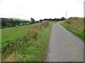
A minor road in Deveronvale
This scenic road is used by the National Cycle Network between Banff and Turriff.
Image: © Richard Webb
Taken: 4 Aug 2011
0.12 miles
9
Bere Haugh
Barley growing on what seems from the name, a place long associated with arable agriculture.
Image: © Richard Webb
Taken: 4 Aug 2011
0.20 miles
10
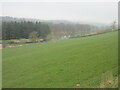
Field above the Deveron
Green field sloping down on the eastern side of the River Deveron near Boghead.
Image: © Scott Cormie
Taken: 16 Apr 2022
0.21 miles