IMAGES TAKEN NEAR TO
Forgue Road, INVERURIE, AB51 8UE
Introduction
This page details the photographs taken nearby to Forgue Road, AB51 8UE by members of the Geograph project.
The Geograph project started in 2005 with the aim of publishing, organising and preserving representative images for every square kilometre of Great Britain, Ireland and the Isle of Man.

There are currently over 7.5m images from over14,400 individuals and you can help contribute to the project by visiting https://www.geograph.org.uk
Image Map
Images are licensed for reuse under creativecommons.org/licenses/by-sa/2.0
Notes
- Clicking on the map will re-center to the selected point.
- The higher the marker number, the further away the image location is from the centre of the postcode.
Image Listing (15 Images Found)
Images are licensed for reuse under creativecommons.org/licenses/by-sa/2.0
Image
Details
Distance
2
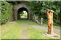
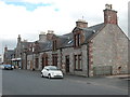
Rothienorman railway station (site), Aberdeenshire
Opened in 1857 by the Banff Macduff & Turriff Junction Railway, later part of the Great North of Scotland Railway, on the line from Inveramsay to Macduff, this station closed to passengers in 1951 and completely in 1966.
View south on the former track-bed towards Wartle and Inveramsay. The main station building would have been to the right. It is now a car park.
Image: © Nigel Thompson
Taken: 6 Sep 2019
0.10 miles
3
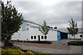
Rothienorman Primary School
This is presumably the school hall, hence the lack of windows.
Image: © Bill Harrison
Taken: 1 Jul 2017
0.12 miles
4
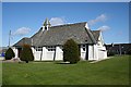
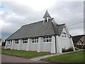
Rothienorman Parish Kirk
This is a most unusual, definitely not traditional, style of kirk. It was designed by George Bennett Mitchell and Son and built in 1935/6.
Image: © Anne Burgess
Taken: 7 May 2009
0.15 miles
5
Rothienorman Parish Church
A striking and highly unusual rural church from the 1930s, designed by George Mitchell: http://www.scottisharchitects.org.uk/architect_full.php?id=202122 . The Buildings of Scotland guide calls it "late Arts and Crafts". The stone just visible above the flowerbed reads: Foundation stone / 8th June 1936.
Image: © Bill Harrison
Taken: 1 Jul 2017
0.16 miles
6
Rothienorman
Industry and residential cheek by jowl in the village of Rothienorman.
Image: © Anne Burgess
Taken: 7 May 2009
0.16 miles
7
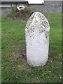
Old Milestone by the B9001, Forgue Road, Rothienorman
Double bevel milestone by the B9001, in parish of Fyvie (Grampian District), Forgue Road, Rothienorman, on verge opposite playground.
Inscription reads:-
: Ab(erdeen) / 26 : : In(verurie) / 10 :
Surveyed
Milestone Society National ID: AD_ADIU26
Image: © Milestone Society
Taken: Unknown
0.17 miles
8
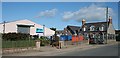
Main Street, Rothienorman...
...incorporating the village shop and Post Office.
Image: © Bill Harrison
Taken: 1 Jul 2017
0.21 miles
9
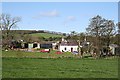
Mill of Meadaple
A busy-looking farm just outside the village of Rothienorman. The hill in the background is the Hill of Kinbroon.
Image: © Anne Burgess
Taken: 7 May 2009
0.22 miles
10
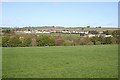
Rothienorman
The village from the other side of the glen of the Fordoun Burn.
Image: © Anne Burgess
Taken: 7 May 2009
0.22 miles