IMAGES TAKEN NEAR TO
St. James's Place, INVERURIE, AB51 3UB
Introduction
This page details the photographs taken nearby to St. James's Place, AB51 3UB by members of the Geograph project.
The Geograph project started in 2005 with the aim of publishing, organising and preserving representative images for every square kilometre of Great Britain, Ireland and the Isle of Man.

There are currently over 7.5m images from over14,400 individuals and you can help contribute to the project by visiting https://www.geograph.org.uk
Image Map
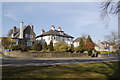
Images are licensed for reuse under creativecommons.org/licenses/by-sa/2.0
Notes
- Clicking on the map will re-center to the selected point.
- The higher the marker number, the further away the image location is from the centre of the postcode.
Image Listing (70 Images Found)
Images are licensed for reuse under creativecommons.org/licenses/by-sa/2.0
Image
Details
Distance
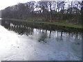
2
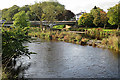
Inverurie Bridge
Originally this was the main crossing over the River Don, and until the late 20th century it carried all the traffic to and from Aberdeen and Inverness and all points in between. It is now, fortunately, bypassed by a new main road bridge a few hundred metres upstream which carries all the through traffic. Even so, it can be a bottleneck at busy times. The river divides into two channels here; they rejoin about 400 metres downstream beyond the island of Broom Inch.
Image: © Anne Burgess
Taken: 29 Sep 2017
0.08 miles
3
Inverurie Bridge
Dating from about 1928, it replaced an eighteenth century structure. The bank is now an attractive walk.
Image: © Bill Harrison
Taken: 26 Mar 2012
0.08 miles
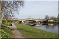
6
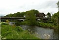
Inverurie Bridge
The B993 crossing the River Don.
Early 20th century replacement for an 18th century predecessor. It was built in 1924 in reinforced concrete on the piers of the previous 18th century stone bridge. The cantilever design means that only minimal forces are transferred to the outer abutments. See also https://www.geograph.org.uk/photo/7183984
Image: © Alan Murray-Rust
Taken: 22 May 2022
0.09 miles
7
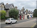
High Street, Inverurie
Shops at the southern end of the street.
Image: © Richard Webb
Taken: 6 Aug 2011
0.09 miles
8
River Don
Both channels of the river can be seen here, with the tip of Broom Inch between them. In the background are houses off Keithhal Road in Inverurie.
Image: © Anne Burgess
Taken: 29 Sep 2017
0.10 miles
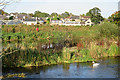
9
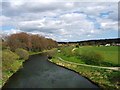
River Don, Inverurie
Looking towards the bridge crossing the Don at Port Elphinstone.
Image: © Linda Laidlaw
Taken: 16 Apr 2007
0.10 miles
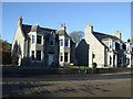
10
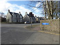
Commercial Road cul-de-sac
Traffic-light controlled junction with High Street (B9001)
Image: © Stanley Howe
Taken: 22 Feb 2018
0.10 miles