IMAGES TAKEN NEAR TO
Morrison Place, BANFF, AB45 1FT
Introduction
This page details the photographs taken nearby to Morrison Place, AB45 1FT by members of the Geograph project.
The Geograph project started in 2005 with the aim of publishing, organising and preserving representative images for every square kilometre of Great Britain, Ireland and the Isle of Man.

There are currently over 7.5m images from over14,400 individuals and you can help contribute to the project by visiting https://www.geograph.org.uk
Image Map
Images are licensed for reuse under creativecommons.org/licenses/by-sa/2.0
Notes
- Clicking on the map will re-center to the selected point.
- The higher the marker number, the further away the image location is from the centre of the postcode.
Image Listing (139 Images Found)
Images are licensed for reuse under creativecommons.org/licenses/by-sa/2.0
Image
Details
Distance
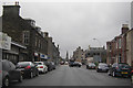
1
Banff Bay is just visible through the trees.
Image: © Des Colhoun
Taken: 13 Sep 2006
0.12 miles
4
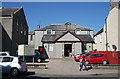
Former Trinity Free Kirk Hall, Castle Street
This building is marked on the mid-Victorian six-inch Ordnance Survey map as a school, and as such must have been associated with the Trinity and Alvah Free Kirk next door. Both buildings are now run as Riverside Church by Harvest Ministries, a small independent Christian denomination. See http://www.harvestministries.org.uk/Groups/129403/Harvest_Ministries/Riverside_Banff/About_Us/About_Us.aspx
Image: © Anne Burgess
Taken: 25 Jul 2014
0.14 miles
5
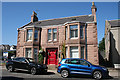
Gardenia House
A Victorian sandstone villa on Castle Street.
Image: © Anne Burgess
Taken: 25 Jul 2014
0.14 miles
6
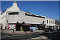
Castlegate Newsagents
Each time I pass along the High Street, this building grates on me. It is so totally out of keeping with the 18th and 19th century houses round about.
Image: © Anne Burgess
Taken: 25 Jul 2014
0.14 miles
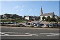
7
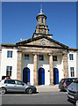
Trinity and Alvah Free Kirk
This kirk is uncharacteristically elaborate for an early Free Kirk. It is cruciform, with an octagonal dome above an Ionic portico. The architect was James Raeburn, from the next parish, Boyndie, and the kirk was built in 1843, almost immediately after the Disruption, when the Rev Francis William Grant and a substantial number of parishioners left the Church of Scotland. It rejoined the Church of Scotland in 1929 and was in use until 1995. It is now an independent church belonging to Harvest Ministries. See http://canmore.rcahms.gov.uk/en/site/172503/details/banff+castle+street+trinity+and+alvah+church/ and http://www.harvestministries.org.uk/Groups/211097/Harvest_Ministries/Riverside_Banff/Trinity_Church_Project/Trinity_Church_Project.aspx
Image: © Anne Burgess
Taken: 25 Jul 2014
0.15 miles
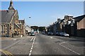
8
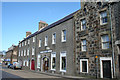
4 - 10 Castle Street
This range of buildings on the east side of Castle Street is all Category B listed, and it is an important feature of Banff's historic townscape. No 4, nearest the camera, dates from the 1850s, and the rest of the range from the 1760s or 1770s.
Image: © Anne Burgess
Taken: 8 Apr 2014
0.15 miles
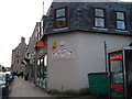
9
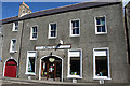
Trend DIY
Trend DIY occupies No 6 Castle Street, a category B listed building from about 1760, which was for a time the Drill Hall of Banff.
Image: © Anne Burgess
Taken: 8 Apr 2014
0.15 miles