Trinity and Alvah Free Kirk
Introduction
The photograph on this page of Trinity and Alvah Free Kirk by Anne Burgess as part of the Geograph project.
The Geograph project started in 2005 with the aim of publishing, organising and preserving representative images for every square kilometre of Great Britain, Ireland and the Isle of Man.

There are currently over 7.5m images from over 14,400 individuals and you can help contribute to the project by visiting https://www.geograph.org.uk
Trinity and Alvah Free Kirk
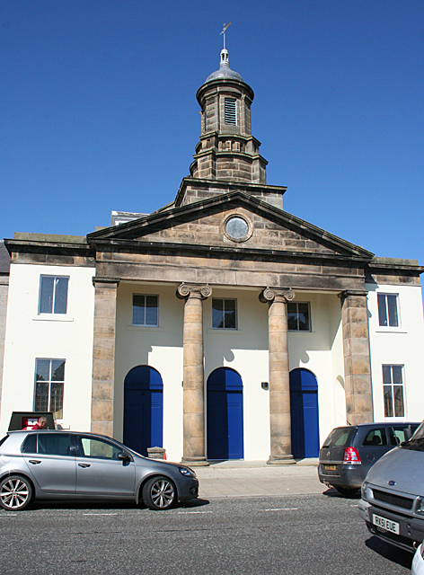
Image: © Anne Burgess Taken: 25 Jul 2014
This kirk is uncharacteristically elaborate for an early Free Kirk. It is cruciform, with an octagonal dome above an Ionic portico. The architect was James Raeburn, from the next parish, Boyndie, and the kirk was built in 1843, almost immediately after the Disruption, when the Rev Francis William Grant and a substantial number of parishioners left the Church of Scotland. It rejoined the Church of Scotland in 1929 and was in use until 1995. It is now an independent church belonging to Harvest Ministries. See http://canmore.rcahms.gov.uk/en/site/172503/details/banff+castle+street+trinity+and+alvah+church/ and http://www.harvestministries.org.uk/Groups/211097/Harvest_Ministries/Riverside_Banff/Trinity_Church_Project/Trinity_Church_Project.aspx
Images are licensed for reuse under creativecommons.org/licenses/by-sa/2.0
Image Location
Latitude
57.665787
Longitude
-2.523785