IMAGES TAKEN NEAR TO
New Aberdour, FRASERBURGH, AB43 7LS
Introduction
This page details the photographs taken nearby to AB43 7LS by members of the Geograph project.
The Geograph project started in 2005 with the aim of publishing, organising and preserving representative images for every square kilometre of Great Britain, Ireland and the Isle of Man.

There are currently over 7.5m images from over14,400 individuals and you can help contribute to the project by visiting https://www.geograph.org.uk
Image Map
Images are licensed for reuse under creativecommons.org/licenses/by-sa/2.0
Notes
- Clicking on the map will re-center to the selected point.
- The higher the marker number, the further away the image location is from the centre of the postcode.
Image Listing (13 Images Found)
Images are licensed for reuse under creativecommons.org/licenses/by-sa/2.0
Image
Details
Distance
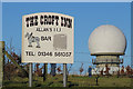
1
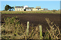
Croft Inn
I was a little surprised to see from both the 1:50,000 map and the 1:25,000 map that there is a public house in the slightly out-of-the way spot, but here it is. The white sphere is not part of the pub - it's Image
Image: © Anne Burgess
Taken: 20 Jan 2017
0.01 miles
3
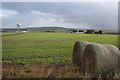
Straw bales, a pub, and an aerial on Allans Hill
Image: © Des Colhoun
Taken: 21 Jan 2007
0.05 miles
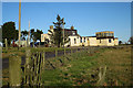
4
Inn Sign
The only thing I could not make up my mind about is whether or not the pub was actually open! In the background is Image
Image: © Anne Burgess
Taken: 20 Jan 2017
0.07 miles
5
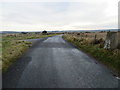
Road at the entrance to Allans Hill Radar Station
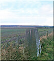
Looking south-eastward from the Triangulation Pillar.
Image: © Peter Wood
Taken: 19 Nov 2019
0.08 miles
6
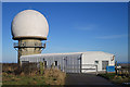
Allanshill Radar Station
The sign by the gate reveals that this is operated by NATS - the National Air Traffic Service.
Image: © Anne Burgess
Taken: 20 Jan 2017
0.11 miles
7
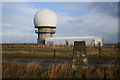
Triangulation Pillar by Allans Hill radar station.
Image: © Des Colhoun
Taken: 21 Jan 2007
0.11 miles
8
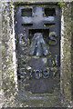
The OS official stamp and "crow's Foot" at Allans Hill.
Image: © Des Colhoun
Taken: 21 Jan 2007
0.11 miles
9
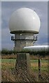
Triangulation pillar and radar station, Alans Hill, Aberdeenshire
The radar station is operated by NATS (National Air Traffic Services). The radome (the "golf ball" which protects the radar antenna) was replaced in 2018: https://www.nats.aero/features/replacing-allanshill-radome/ .
Image: © Claire Pegrum
Taken: 7 Sep 2022
0.11 miles
10
Allanshill Trig Point Flush Bracket S7097
Roadside trigpoint
Image: © thejackrustles
Taken: 10 Nov 2012
0.11 miles