IMAGES TAKEN NEAR TO
Murison Drive, FRASERBURGH, AB43 7JR
Introduction
This page details the photographs taken nearby to Murison Drive, AB43 7JR by members of the Geograph project.
The Geograph project started in 2005 with the aim of publishing, organising and preserving representative images for every square kilometre of Great Britain, Ireland and the Isle of Man.

There are currently over 7.5m images from over14,400 individuals and you can help contribute to the project by visiting https://www.geograph.org.uk
Image Map
Images are licensed for reuse under creativecommons.org/licenses/by-sa/2.0
Notes
- Clicking on the map will re-center to the selected point.
- The higher the marker number, the further away the image location is from the centre of the postcode.
Image Listing (40 Images Found)
Images are licensed for reuse under creativecommons.org/licenses/by-sa/2.0
Image
Details
Distance
1
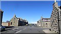
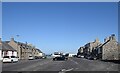
Well Street, Rosehearty
A grid pattern of grey houses.
Image: © Richard Webb
Taken: 15 Apr 2015
0.09 miles
2
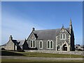
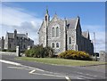
Rosehearty parish kirk
Built 1882 for the United Presbyterians (https://en.wikipedia.org/wiki/United_Presbyterian_Church_(Scotland) ), which was the favoured faith of most of the fishermen in the village and later the established church. Architects: Ellis and Wilson, who designed many public and private buildings in northeast Scotland: http://www.scottisharchitects.org.uk/architect_full.php?id=200676 . ,
Image: © Bill Harrison
Taken: 16 Apr 2021
0.11 miles
4
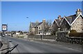
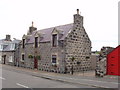
Granite villas, Pitsligo Street, Rosehearty
Image: © Bill Harrison
Taken: 16 Apr 2021
0.16 miles
5
Bed and Breakfast in Rosehearty
This excellent B&B is in Mid Street. We booked it through the helpful Fraserburgh Tourist Office http://guide.visitscotland.com/?branchtype=accommodation .
Image: © David Hawgood
Taken: 11 Sep 2007
0.17 miles
6
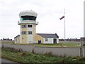
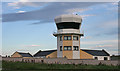
Former bombing range observation tower, Rosehearty
This is now "Rosehearty Tower", a private residence. On 7th May 2002 The Scotsman http://thescotsman.scotsman.com/business.cfm?id=490632002 reported it was under offer as a disposal from the Ministry of Defence, adding "It comes with the added benefit of bomb-proof and bullet-proof windows." Locals told me it cost £750,000 to build and was sold for £75,000. When photographed it had two wind socks, one from a Union Flag and one from a Scottish St Andrew's Cross flag. When built it replaced a building on quarry head, see Image
Image: © David Hawgood
Taken: 11 Sep 2007
0.17 miles
7
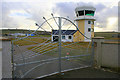
Air Traffic Control at Rosehearty.
Not much in the way of defence cuts here with an elaborate gate like that! An area adjacent to Rosehearty over the sea is designated as a bombing range and maintained by the RAF.
Image: © Des Colhoun
Taken: 21 Jan 2007
0.17 miles
8
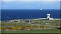
Lookout tower, Rosehearty
Now a private residence, this was a range lookout for a bombing range offshore.
Image: © Richard Webb
Taken: 15 Apr 2015
0.19 miles
9
Rosehearty: the Square
The Square was probably laid out in 1681 but the present buildings are much later.
Image: © Bill Harrison
Taken: 16 Apr 2021
0.19 miles
10
Rosehearty Tower
This is the former control tower for the bombing range offshore that was used by the RAF. It has been converted to housing.
Image: © Anne Burgess
Taken: 30 Aug 2016
0.19 miles