IMAGES TAKEN NEAR TO
Pittendrum Gardens, FRASERBURGH, AB43 7EZ
Introduction
This page details the photographs taken nearby to Pittendrum Gardens, AB43 7EZ by members of the Geograph project.
The Geograph project started in 2005 with the aim of publishing, organising and preserving representative images for every square kilometre of Great Britain, Ireland and the Isle of Man.

There are currently over 7.5m images from over14,400 individuals and you can help contribute to the project by visiting https://www.geograph.org.uk
Image Map
Images are licensed for reuse under creativecommons.org/licenses/by-sa/2.0
Notes
- Clicking on the map will re-center to the selected point.
- The higher the marker number, the further away the image location is from the centre of the postcode.
Image Listing (14 Images Found)
Images are licensed for reuse under creativecommons.org/licenses/by-sa/2.0
Image
Details
Distance
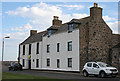
1
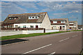
Clinton Drive
20th century houses in an extension of Sandhaven to the south. I wonder who the Clinton was after whom the street was named?
Image: © Anne Burgess
Taken: 30 Aug 2016
0.05 miles
2
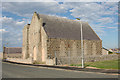
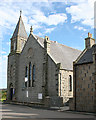
Village Hall
This is obviously a former kirk, and a notice on the other side says it is a community hall. The map also says 'hall', but I wonder if perhaps it is no longer in use as such?
Image: © Anne Burgess
Taken: 30 Aug 2016
0.10 miles
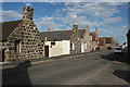
3
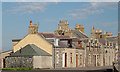
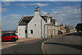
Main Street
The main street is lined with mid-19th century stone houses.
Image: © Anne Burgess
Taken: 30 Aug 2016
0.11 miles
4
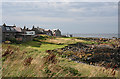
Pittulie
Pittulie is contiguous with Sandhaven, but is much older, with traditional cottages mostly gable-end to the sea.
Image: © Anne Burgess
Taken: 30 Aug 2016
0.11 miles
5
Sandhaven Kirk
The kirk dates from the late 19th century. The interior is uncompromisingly plain and free of adornment.
Image: © Anne Burgess
Taken: 30 Aug 2016
0.13 miles
6
High Street, Pittulie
This is the east end of the single street that makes up Pittulie. Here, the houses are aligned with their long elevations to the street.
Image: © Anne Burgess
Taken: 30 Aug 2016
0.17 miles
7
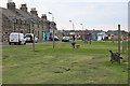
Drying Green
Many of the fishing villages on the east coast have communal drying greens on the shore.
Image: © Anne Burgess
Taken: 30 Aug 2016
0.18 miles
8
Sandhaven
The drying green provides a clear gap between the houses and the sea.
Image: © Anne Burgess
Taken: 30 Aug 2016
0.19 miles
9
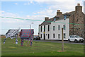
Houses in Sandhaven
Tradition houses with an 18th century look to them, though it's uncommon to find three-storey houses in small fishing villages.
Image: © Anne Burgess
Taken: 30 Aug 2016
0.19 miles
10
Pittulie Main Street
There isn't much more of Pittulie than just the one street. The houses are built with their gable ends to the sea, thus being less exposed to the north and to winter storms.
Image: © Anne Burgess
Taken: 30 Aug 2016
0.23 miles