IMAGES TAKEN NEAR TO
New Pitsligo, FRASERBURGH, AB43 6PT
Introduction
This page details the photographs taken nearby to AB43 6PT by members of the Geograph project.
The Geograph project started in 2005 with the aim of publishing, organising and preserving representative images for every square kilometre of Great Britain, Ireland and the Isle of Man.

There are currently over 7.5m images from over14,400 individuals and you can help contribute to the project by visiting https://www.geograph.org.uk
Image Map
Images are licensed for reuse under creativecommons.org/licenses/by-sa/2.0
Notes
- Clicking on the map will re-center to the selected point.
- The higher the marker number, the further away the image location is from the centre of the postcode.
Image Listing (6 Images Found)
Images are licensed for reuse under creativecommons.org/licenses/by-sa/2.0
Image
Details
Distance
1
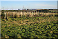
New Plantation near Glasslaw
Plastic sheaths protect young saplings in regimented straight lines in a newish woodland by the road side.
Image: © Anne Burgess
Taken: 20 Jan 2017
0.07 miles
2
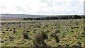
Young trees, Bogfold
Rows of Tuley tube.
Image: © Richard Webb
Taken: 15 Apr 2015
0.11 miles
3
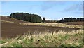
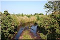
Wetland, Bogfold
The floor of a reentrant is not draining, leaving rough grassland amongst better drained sloping arable land.
Image: © Richard Webb
Taken: 15 Apr 2015
0.20 miles
5
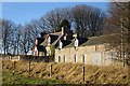
Glasslaw
The traditional house and farm buildings stand beside the minor road.
Image: © Anne Burgess
Taken: 20 Jan 2017
0.23 miles
6
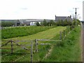
Flooded Track
It was surprising to see such a large amount of water still lying in spite of the recent warm dry weather. Fortunately it was not difficult to get round it.
Image: © Anne Burgess
Taken: 2 Jul 2009
0.23 miles