IMAGES TAKEN NEAR TO
Windhill Street, PETERHEAD, AB42 5DR
Introduction
This page details the photographs taken nearby to Windhill Street, AB42 5DR by members of the Geograph project.
The Geograph project started in 2005 with the aim of publishing, organising and preserving representative images for every square kilometre of Great Britain, Ireland and the Isle of Man.

There are currently over 7.5m images from over14,400 individuals and you can help contribute to the project by visiting https://www.geograph.org.uk
Image Map
Images are licensed for reuse under creativecommons.org/licenses/by-sa/2.0
Notes
- Clicking on the map will re-center to the selected point.
- The higher the marker number, the further away the image location is from the centre of the postcode.
Image Listing (20 Images Found)
Images are licensed for reuse under creativecommons.org/licenses/by-sa/2.0
Image
Details
Distance
1
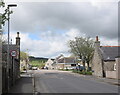
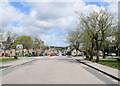
Looking west along Knock Street, Stuartfield...
...with Scrog Hill in the distance.
Image: © Bill Harrison
Taken: 22 May 2021
0.06 miles
2
Village shop, The Square, Stuartfield
Image: © Bill Harrison
Taken: 22 May 2021
0.08 miles
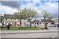
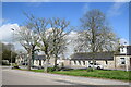
3
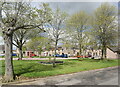
The Square, Stuartfield
Stuartfield is an improvement village dating from ca. 1772 with the streets laid out on a grid pattern and centred on The Square, seen here. Note the Millennium bell (https://www.geograph.org.uk/photo/1198703 ) to the right of the crossroads: interestingly a 'bell pole' is shown on the same spot on the 1900 25-inch OS map of Stuartfield. There is a Canmore listing for the village (120125: https://canmore.org.uk/site/120125/stuartfield ) but no details are given.
Image: © Bill Harrison
Taken: 16 May 2021
0.08 miles
4
Village pump, The Square, Stuartfield
The non-functional pump serves as the emblem for Stuartfield primary school.
Image: © Bill Harrison
Taken: 22 May 2021
0.09 miles
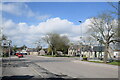
5
Village view of Stuartfield
Looking north along the wide main street of the attractive improvement village dating from ca. 1772, which once housed weavers but now mostly commuters. There is a Canmore listing (120125: https://canmore.org.uk/site/120125/stuartfield ) but no details are given.
Image: © Bill Harrison
Taken: 22 May 2021
0.09 miles
7

Village butcher and post office, Stuartfield
The tiny shop accommodates the unusual combination of the butchers and village post office as well as a bakery and deli. The OS map suggests that the post office was once on the opposite side of the road.
Image: © Bill Harrison
Taken: 22 May 2021
0.09 miles
8
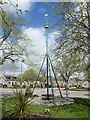
Millennium bell, Stuartfield
A striking edifice erected for the millennium to take the place of a similar structure that once summoned villagers to their employment at the mills at the south and north ends of the village and was dismantled around 1900. The present bell comes from the former free church, which was demolished in the 1970s, allowing village history to live on in a very effective way.
Image: © Bill Harrison
Taken: 22 May 2021
0.09 miles
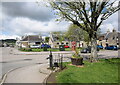
9
A sunny corner of Stuartfield
The north-east corner of the village square catches the sunlight on a spring day.
Image: © Bill Harrison
Taken: 22 May 2021
0.10 miles
10
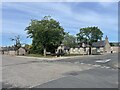
View across the Square towards Knock Street, Stuartfield
Note the single-storey former weavers' cottages.
Image: © Bill Harrison
Taken: 16 May 2021
0.10 miles