IMAGES TAKEN NEAR TO
Blackhouse Way, PETERHEAD, AB42 1BQ
Introduction
This page details the photographs taken nearby to Blackhouse Way, AB42 1BQ by members of the Geograph project.
The Geograph project started in 2005 with the aim of publishing, organising and preserving representative images for every square kilometre of Great Britain, Ireland and the Isle of Man.

There are currently over 7.5m images from over14,400 individuals and you can help contribute to the project by visiting https://www.geograph.org.uk
Image Map
Images are licensed for reuse under creativecommons.org/licenses/by-sa/2.0
Notes
- Clicking on the map will re-center to the selected point.
- The higher the marker number, the further away the image location is from the centre of the postcode.
Image Listing (10 Images Found)
Images are licensed for reuse under creativecommons.org/licenses/by-sa/2.0
Image
Details
Distance
3
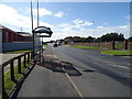
Bus stop and shelter on Windmill Road, Peterhead
Image: © JThomas
Taken: 21 Aug 2020
0.19 miles
4
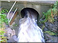
The Collie Burn
The Collie Burn enters a culvert to take it beneath the A982 on its way to join the river Ugie.
Image: © Iain Smith
Taken: 30 Sep 2010
0.21 miles
6
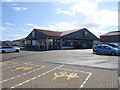
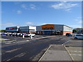
Out of town shops
A mix of shops here including Halfords, Homebargains and Lidl
Image: © Ralph Greig
Taken: 8 Mar 2023
0.22 miles
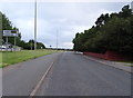
9
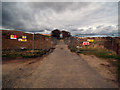
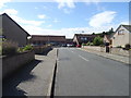
Inverugie Road, Peterhead
I'm always saddened to see places where I used to play as a youngster being developed with yet more green space being lost forever, but that's progress I suppose.
This is the Inverugie Road in Peterhead, showing the security fencing that has been erected around a massive new housing development, and which currently blocks the road. Whether or not the road will be reinstated at a later date, I have no idea.
Leading off to the right is the pathway running alongside the Collie Burn.
Image: © Iain Smith
Taken: 23 Mar 2011
0.23 miles