IMAGES TAKEN NEAR TO
Hatton, PETERHEAD, AB42 0RX
Introduction
This page details the photographs taken nearby to AB42 0RX by members of the Geograph project.
The Geograph project started in 2005 with the aim of publishing, organising and preserving representative images for every square kilometre of Great Britain, Ireland and the Isle of Man.

There are currently over 7.5m images from over14,400 individuals and you can help contribute to the project by visiting https://www.geograph.org.uk
Image Map
Images are licensed for reuse under creativecommons.org/licenses/by-sa/2.0
Notes
- Clicking on the map will re-center to the selected point.
- The higher the marker number, the further away the image location is from the centre of the postcode.
Image Listing (7 Images Found)
Images are licensed for reuse under creativecommons.org/licenses/by-sa/2.0
Image
Details
Distance
1
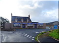
The Station Hotel, Hatton
On the side of the former railway from Boddam to Ellon.
Image: © JThomas
Taken: 23 Aug 2020
0.03 miles
2
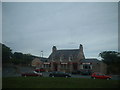
Hatton, Station Hotel
typical small village pub / hotel
Image: © Ken Fitlike
Taken: 20 Sep 2002
0.05 miles
4
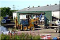
GNSR Goods Shed, Hatton, Aberdeenshire
Dismantling of the only surviving GNSR goods shed is well under way back in July 2009. The shed is now completely gone.
Some good info about this shed, and other local history, can be found here...
http://theatreorgans.com/hammond/keng/kenhtml/Boddam%20To%20Ellon/HattonStationSite.htm
Image: © Iain Smith
Taken: 31 Jul 2009
0.07 miles
5
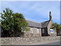
Hatton (Cruden) School
School roll (2017-18): 94 in five composite classes.
Image: © Bill Harrison
Taken: 19 May 2018
0.22 miles
6
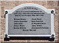
Hatton war memorial
Now attached to the community hall after the church was destroyed by fire in 2015 and was demolished as unsafe. Atypically, neither rank nor regiment of the fallen are specified.
Image: © Bill Harrison
Taken: 19 May 2018
0.24 miles
7
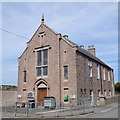
Hatton community hall
Quite a lavish two-storey structure from 1905 for a small village with "Tudor-Jacobean gable front" as the Buildings of Scotland (Pevsner) Guide puts it. Note the war memorial plaque to the left of the doors, which formerly adorned Cruden West kirk (see: https://www.geograph.org.uk/photo/237552 ) a few hundred metres to the west, until it burned down in 2015.
Image: © Bill Harrison
Taken: 19 May 2018
0.25 miles