IMAGES TAKEN NEAR TO
Quarry Road, PETERHEAD, AB42 0HL
Introduction
This page details the photographs taken nearby to Quarry Road, AB42 0HL by members of the Geograph project.
The Geograph project started in 2005 with the aim of publishing, organising and preserving representative images for every square kilometre of Great Britain, Ireland and the Isle of Man.

There are currently over 7.5m images from over14,400 individuals and you can help contribute to the project by visiting https://www.geograph.org.uk
Image Map
Images are licensed for reuse under creativecommons.org/licenses/by-sa/2.0
Notes
- Clicking on the map will re-center to the selected point.
- The higher the marker number, the further away the image location is from the centre of the postcode.
Image Listing (10 Images Found)
Images are licensed for reuse under creativecommons.org/licenses/by-sa/2.0
Image
Details
Distance
1
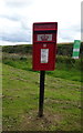
Elizabethan postbox on Hatton Farm Gardens, Hatton
Postbox No. AB42 42.
Image: © JThomas
Taken: 23 Aug 2020
0.06 miles
2
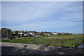
Hatton village centre
The burn just visible to the right joins others to become the Water of Cruden a couple of kilometres to the east.
Image: © Bill Harrison
Taken: 19 May 2018
0.10 miles
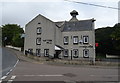
4
Hatton Mill
old village water mill buildings refurbished in the late 70s into a nice pub
Image: © Ken Fitlike
Taken: 11 Sep 2006
0.16 miles
5
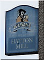
Sign for the Hatton Mill, Hatton
See Image] for context.
Image: © JThomas
Taken: 23 Aug 2020
0.16 miles
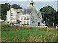
6
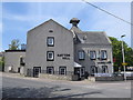
Hatton Mill
The village mill from 1849 and now a nice pub conversion with the kiln tower still prominent.
Image: © Bill Harrison
Taken: 19 May 2018
0.16 miles
7
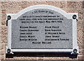
Hatton war memorial
Now attached to the community hall after the church was destroyed by fire in 2015 and was demolished as unsafe. Atypically, neither rank nor regiment of the fallen are specified.
Image: © Bill Harrison
Taken: 19 May 2018
0.16 miles
8
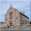
Hatton community hall
Quite a lavish two-storey structure from 1905 for a small village with "Tudor-Jacobean gable front" as the Buildings of Scotland (Pevsner) Guide puts it. Note the war memorial plaque to the left of the doors, which formerly adorned Cruden West kirk (see: https://www.geograph.org.uk/photo/237552 ) a few hundred metres to the west, until it burned down in 2015.
Image: © Bill Harrison
Taken: 19 May 2018
0.17 miles
9
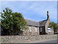
Hatton (Cruden) School
School roll (2017-18): 94 in five composite classes.
Image: © Bill Harrison
Taken: 19 May 2018
0.17 miles
10
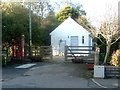
Hatton telephone exchange
Hatton has a rather tidy telephone exchange on its main street. The troughs in front often contain flowers, though they were empty on this October visit.
Image: © Haworth Hodgkinson
Taken: 17 Oct 2016
0.22 miles