IMAGES TAKEN NEAR TO
Ogston Road, ELLON, AB41 9DG
Introduction
This page details the photographs taken nearby to Ogston Road, AB41 9DG by members of the Geograph project.
The Geograph project started in 2005 with the aim of publishing, organising and preserving representative images for every square kilometre of Great Britain, Ireland and the Isle of Man.

There are currently over 7.5m images from over14,400 individuals and you can help contribute to the project by visiting https://www.geograph.org.uk
Image Map
Images are licensed for reuse under creativecommons.org/licenses/by-sa/2.0
Notes
- Clicking on the map will re-center to the selected point.
- The higher the marker number, the further away the image location is from the centre of the postcode.
Image Listing (17 Images Found)
Images are licensed for reuse under creativecommons.org/licenses/by-sa/2.0
Image
Details
Distance
1
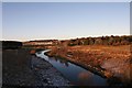
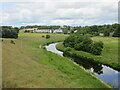
River Ythan from the Bridge
Taken from an old rail bridge over the Ythan this is a westerly view with Meiklemill Woods on the left and housing at Esslemont Circle in Auchterellon on the right.
Image: © Andrew Wood
Taken: 9 Jan 2011
0.09 miles
2
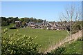
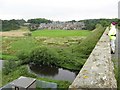
Ellon
This is as far as the western outskirts of Ellon extended until the expansion of the town in recent decades. The view is from the former railway viaduct.
Image: © Anne Burgess
Taken: 11 May 2009
0.11 miles
3
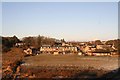
Forrester Terrace
A view of Forrester Terrace and Auchterellon from the old rail bridge over the Ythan.
Image: © Andrew Wood
Taken: 9 Jan 2011
0.14 miles
4
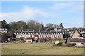
Foresters' Terrace, Ellon?
...with the Scottish Baronial edifice of Auchtercrag (now flats) just visible in the background. Thanks to Elaine for correcting the caption.
Image: © Bill Harrison
Taken: 23 Feb 2020
0.14 miles
5
River Ythan
The River Ythan upstream, viewed from the old railway bridge.
Image: © Scott Cormie
Taken: 18 Jul 2023
0.15 miles
6
Ellon and Ythan
View from the cycle track on the Ellon viaduct over the river Ythan toward the outskirts of Ellon.
Image: © Mike and Kirsty Grundy
Taken: 25 Jul 2007
0.16 miles
7
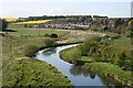
River Ythan
Looking upstream from the former railway viaduct towards a large housing estate on the western outskirts of Ellon.
Image: © Anne Burgess
Taken: 11 May 2009
0.20 miles
8
Ellon station (remains), 1997
View NE, towards Maud and Fraserburgh/Peterhead, also Boddam: ex-GNSR Aberdeen - Dyce - Fraserburgh/Peterhead line, junction of branch to Boddam. The station had closed to passengers 4/10/65 (goods 11/9/67), although freight to Fraserburgh continued until 6/10/79. The Boddam branch lost its passenger service 13/10/32 and closed completely 1/1/49.
Image: © Ben Brooksbank
Taken: 4 Jul 1997
0.22 miles
9
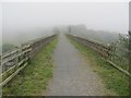
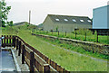
Ellon Viaduct, Formartine and Buchan Railway
The southern approach to the viaduct which now carries a footpath /cycle path.
Image: © Richard Webb
Taken: 4 Aug 2011
0.23 miles
10
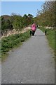
Formartine and Buchan Way
This is part of the former railway line, now converted into a long-distance walking and cycling route, but also popular with local people for shorter walks.
Image: © Anne Burgess
Taken: 11 May 2009
0.23 miles