IMAGES TAKEN NEAR TO
Drumlithie, STONEHAVEN, AB39 3YH
Introduction
This page details the photographs taken nearby to AB39 3YH by members of the Geograph project.
The Geograph project started in 2005 with the aim of publishing, organising and preserving representative images for every square kilometre of Great Britain, Ireland and the Isle of Man.

There are currently over 7.5m images from over14,400 individuals and you can help contribute to the project by visiting https://www.geograph.org.uk
Image Map
Images are licensed for reuse under creativecommons.org/licenses/by-sa/2.0
Notes
- Clicking on the map will re-center to the selected point.
- The higher the marker number, the further away the image location is from the centre of the postcode.
Image Listing (5 Images Found)
Images are licensed for reuse under creativecommons.org/licenses/by-sa/2.0
Image
Details
Distance
1
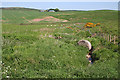
Hidden Burn
Well, almost hidden among the vegetation. It is unnamed. I would be interested to know where the bale rolled down from! The distant farm is Pitdrichie.
Image: © Anne Burgess
Taken: 6 Jun 2013
0.09 miles
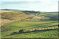
2
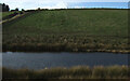
Pond and hillside grazing near Little Bogburn
Image: © JThomas
Taken: 8 Nov 2013
0.11 miles
3
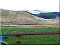
Rail line between Stonehaven and Laurencekirk
Following Bog Burn and its pools. Viewed from minor road near Little Bogburn.
Image: © Stanley Howe
Taken: 29 Mar 2019
0.17 miles
4
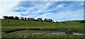
Pond beside the railway at Little Bogburn, Drumlithie
Image: © Mike Pennington
Taken: 20 Jun 2022
0.19 miles
5
Farmland and main rail line between Aberdeen and Dundee
Image: © Steven Brown
Taken: 9 Jan 2013
0.22 miles