IMAGES TAKEN NEAR TO
Glenbuchat, STRATHDON, AB36 8TQ
Introduction
This page details the photographs taken nearby to AB36 8TQ by members of the Geograph project.
The Geograph project started in 2005 with the aim of publishing, organising and preserving representative images for every square kilometre of Great Britain, Ireland and the Isle of Man.

There are currently over 7.5m images from over14,400 individuals and you can help contribute to the project by visiting https://www.geograph.org.uk
Image Map
Images are licensed for reuse under creativecommons.org/licenses/by-sa/2.0
Notes
- Clicking on the map will re-center to the selected point.
- The higher the marker number, the further away the image location is from the centre of the postcode.
Image Listing (4 Images Found)
Images are licensed for reuse under creativecommons.org/licenses/by-sa/2.0
Image
Details
Distance
1
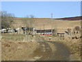
Blackhillock
Looking up the track to the farm from the road.
Image: © Liz Burn
Taken: 19 Feb 2008
0.02 miles
2
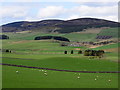
View up Glen Buchat
The Water of Buchat can just be made out snaking around the cluster of trees in the right middle-distance with Blackhillock farm visible farther back and beyond it the trio (from left-to-right) of Clachmaddy hill, Meikle Firbriggs hill and Little Firbriggs hill.
Image: © Bill Harrison
Taken: 28 Apr 2019
0.05 miles
3
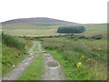
Farm Track, Blackhillock
Two tracks lead from the back of Blackhillock Farm. The better track [this one] leads to nowhere in particular, whilst the less well defined track [off picture to right] leads up on to a ridge.
Image: © Gordon Hatton
Taken: 7 Aug 2008
0.12 miles
4
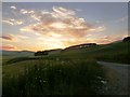
Glen Buchat sunset
Taken from close to the entrance to Blackhillock.
Image: © Alan O'Dowd
Taken: 21 Jul 2013
0.12 miles