IMAGES TAKEN NEAR TO
Kincardine O'Neil, ABOYNE, AB34 5AG
Introduction
This page details the photographs taken nearby to AB34 5AG by members of the Geograph project.
The Geograph project started in 2005 with the aim of publishing, organising and preserving representative images for every square kilometre of Great Britain, Ireland and the Isle of Man.

There are currently over 7.5m images from over14,400 individuals and you can help contribute to the project by visiting https://www.geograph.org.uk
Image Map
Images are licensed for reuse under creativecommons.org/licenses/by-sa/2.0
Notes
- Clicking on the map will re-center to the selected point.
- The higher the marker number, the further away the image location is from the centre of the postcode.
Image Listing (14 Images Found)
Images are licensed for reuse under creativecommons.org/licenses/by-sa/2.0
Image
Details
Distance
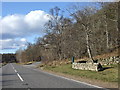
1
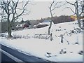
Approaching a snowy Cordach
On A93 from Potarch.
Image: © Stanley Howe
Taken: 28 Dec 2009
0.01 miles
2
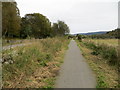
Cycle and Pathway beside the A93 at Cordach
Looking south-eastward.
Image: © Peter Wood
Taken: 13 Oct 2019
0.05 miles
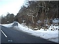
3
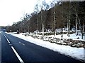
A93 by Cordach
Approaching Tillydrine junction.
Image: © Stanley Howe
Taken: 28 Dec 2009
0.06 miles
4
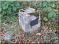
Ordnance Survey Fundamental Benchmark
This can be found on land beside the A93 near to Cordach. The benchmark's recorded height is 93.9 metres above sea level.
For more detail see : https://www.bench-marks.org.uk/bm1001
Image: © Peter Wood
Taken: 13 Oct 2019
0.06 miles
5
Marker post by A93
The green post appears to be near the site of an OS benchmark (93.94m), located between Cordach cottage (off right) and the Tillydrine road fork ahead.
Image: © Stanley Howe
Taken: 9 Mar 2007
0.07 miles
6
Road junction
Where minor road from Tillydrine merges with the North Deeside Road (A93) at Cordach.
Image: © Stanley Howe
Taken: 24 Mar 2011
0.08 miles
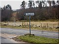
7
Tillydrine road
Access from A93 by Cordach.
Image: © Stanley Howe
Taken: 28 Dec 2009
0.11 miles
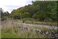
8
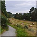
Deeside Way near Potarch
A very narrow field between steep ground and the Dee. The route crosses at the bridge at Potarch, background, and continues through the distant Blackhall Forest before taking the railway trackbed into Aberdeen.
Image: © Richard Webb
Taken: 14 Sep 2019
0.13 miles
10
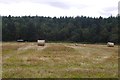
Stubble near Potarch
There is a hut beside the Dee in the background.
Image: © Richard Webb
Taken: 14 Sep 2019
0.17 miles