IMAGES TAKEN NEAR TO
AB2 0WZ
Introduction
This page details the photographs taken nearby to AB2 0WZ by members of the Geograph project.
The Geograph project started in 2005 with the aim of publishing, organising and preserving representative images for every square kilometre of Great Britain, Ireland and the Isle of Man.

There are currently over 7.5m images from over14,400 individuals and you can help contribute to the project by visiting https://www.geograph.org.uk
Image Map
Images are licensed for reuse under creativecommons.org/licenses/by-sa/2.0
Notes
- Clicking on the map will re-center to the selected point.
- The higher the marker number, the further away the image location is from the centre of the postcode.
Image Listing (21 Images Found)
Images are licensed for reuse under creativecommons.org/licenses/by-sa/2.0
Image
Details
Distance
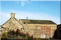
1

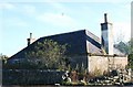
Derelict cottages, Newmachar
The dwellings are named as Mameulah Cottages on old OS maps and were presumably associated with the eponymous farm, a few hundred metres to the north. 'Mameulah' means a dark-coloured hill according to Celtic Placenames in Aberdeenshire by John Milne.
Image: © Bill Harrison
Taken: 13 Mar 2021
0.01 miles
2
Ruined Cottage
Not the most desirable accommodation in Newmachar.
Image: © Andrew Wood
Taken: 8 Oct 2008
0.02 miles
3
Ruined cottage beside the driveway to Mameulah Farm
Image: © Bill Harrison
Taken: 13 Mar 2021
0.03 miles
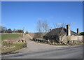
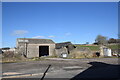
4
Farm no more
On the edge of Newmachar these buildings have fallen badly into disrepair presumably because land has been used for housing.
Image: © Andrew Wood
Taken: 8 Oct 2008
0.06 miles
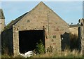
6
Ruined Barn
Lying beside the pub at Newmachar this farm building has fallen into severe disrepair .
Image: © Andrew Wood
Taken: 8 Oct 2008
0.08 miles
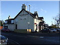
7
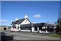
The Newmachar Hotel
The hotel, formerly the Newmachar Inn, is on the main road at the north of the village.
Image: © Bill Harrison
Taken: 13 Mar 2021
0.08 miles
8
Derelict farm buildings, Newmachar
This was once part of the hamlet of Reisque, but now forms the boundary of Newmachar village. Reisque or Risque means 'wet or soft mossy ground covered with coarse grass' according to Celtic Placenames in Aberdeenshire by John Milne.
Image: © Bill Harrison
Taken: 13 Mar 2021
0.09 miles
9
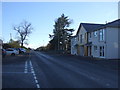
Oldmeldrum Road (A947), Newmachar
Towards Aberdeen.
Image: © JThomas
Taken: 9 Nov 2013
0.09 miles
10
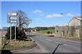
Looking north along the A947
The junction was once the hamlet of Reisque, but it has now been subsumed by housing and is the northern boundary of Newmachar.
Image: © Bill Harrison
Taken: 13 Mar 2021
0.10 miles