IMAGES TAKEN NEAR TO
Coast Road, ABERDEEN, AB12 3LT
Introduction
This page details the photographs taken nearby to Coast Road, AB12 3LT by members of the Geograph project.
The Geograph project started in 2005 with the aim of publishing, organising and preserving representative images for every square kilometre of Great Britain, Ireland and the Isle of Man.

There are currently over 7.5m images from over14,400 individuals and you can help contribute to the project by visiting https://www.geograph.org.uk
Image Map
Images are licensed for reuse under creativecommons.org/licenses/by-sa/2.0
Notes
- Clicking on the map will re-center to the selected point.
- The higher the marker number, the further away the image location is from the centre of the postcode.
Image Listing (41 Images Found)
Images are licensed for reuse under creativecommons.org/licenses/by-sa/2.0
Image
Details
Distance
1
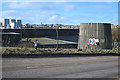
Nigg Waste Water Treatment Plant
I wonder how the Aberdeen Harbour expansion will affect this? It surely won't be able to discharge treated water through the harbour? In the background are houses and tower blocks at Balnagask.
Image: © Anne Burgess
Taken: 9 Mar 2018
0.01 miles
2
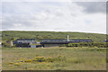
Nigg Bay sewage pumping works
Well, somebody had to take it...
Image: © Bill Harrison
Taken: 15 Jun 2008
0.03 miles
3
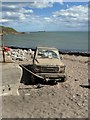
Abandoned Car tethered to the Nigg Breakwater
Image: © Iain Lees
Taken: 21 Aug 2010
0.09 miles
4
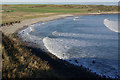
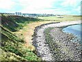
Nigg Bay
Wide expanse of mainly shingle to the south of Girdle Ness.
Image: © Stephen McKay
Taken: 7 Nov 2010
0.09 miles
5
Cliffs in the Bay of Nigg 2003
The flat platform at the foot of the cliffs was added in the 1960s - note how it has been eroded since then. Click http://www.geograph.org.uk/photo/1325292 to see the change in 6 years.
Image: © Peter Robinson
Taken: Unknown
0.09 miles
7
Nigg Bay
Not a very alluring view, really. But make the most of it, because in a couple of years' time this will all be smothered by acres of concrete. See http://www.ahep.co.uk/project.aspx. One of the security guards assured me that it would all be much nicer when it is completed.
Image: © Anne Burgess
Taken: 9 Mar 2018
0.11 miles
8
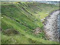
Bay of Nigg South Side in 2009
Note the marine erosion of the man made platform put there in the 1960s to protect the cliffs. Note the fenced-off area where a stream has increased in discharge and is making the ground boggy.
Image: © Peter Robinson
Taken: 28 May 2009
0.12 miles
9
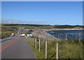
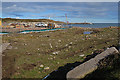
Driving past the new harbour
The new southern Aberdeen Harbour -- which will supposedly accommodate cruise ships -- has proven controversial and expensive and is far from complete in August 2020. Compare this view to Richard Slessor's photo from 2004: https://www.geograph.org.uk/photo/94948 .
Image: © Bill Harrison
Taken: 31 Aug 2020
0.12 miles
10
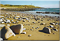
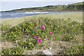
Bay of Nigg
Rocks rounded by the sea are common on the sand at Nigg. In the distance is Girdleness lighthouse. In the geological past, Nigg Bay was the rivermouth of the Dee - it now reaches the sea to the north of Girdleness.
Image: © Colin Smith
Taken: Unknown
0.14 miles