IMAGES TAKEN NEAR TO
Girlsta, SHETLAND, ZE2 9SQ
Introduction
This page details the photographs taken nearby to ZE2 9SQ by members of the Geograph project.
The Geograph project started in 2005 with the aim of publishing, organising and preserving representative images for every square kilometre of Great Britain, Ireland and the Isle of Man.

There are currently over 7.5m images from over14,400 individuals and you can help contribute to the project by visiting https://www.geograph.org.uk
Image Map
Images are licensed for reuse under creativecommons.org/licenses/by-sa/2.0
Notes
- Clicking on the map will re-center to the selected point.
- The higher the marker number, the further away the image location is from the centre of the postcode.
Image Listing (7 Images Found)
Images are licensed for reuse under creativecommons.org/licenses/by-sa/2.0
Image
Details
Distance
2
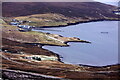
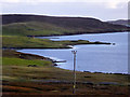
Chalder Ness, Wadbister Voe
Looking across Wadbister Voe to Wadbister.
Image: © Mike Pennington
Taken: 9 Dec 2007
0.09 miles
3
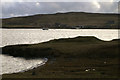
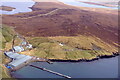
Haar over Wadbister Voe
Chalder Ness in the foreground, haar over Ritta Taing in the background.
Image: © Mike Pennington
Taken: 28 May 2014
0.09 miles
6
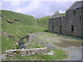
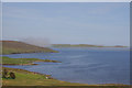
Girlsta burn
The outflow burn from the loch of Girlsta. In the past a large mill was in operation at Girlsta and the crofters came here with their corn to be ground into flour.
Image: © Robert Sandison
Taken: 17 May 2004
0.24 miles