IMAGES TAKEN NEAR TO
Chester Court Road, SELBY, YO8 8JD
Introduction
This page details the photographs taken nearby to Chester Court Road, YO8 8JD by members of the Geograph project.
The Geograph project started in 2005 with the aim of publishing, organising and preserving representative images for every square kilometre of Great Britain, Ireland and the Isle of Man.

There are currently over 7.5m images from over14,400 individuals and you can help contribute to the project by visiting https://www.geograph.org.uk
Image Map
Images are licensed for reuse under creativecommons.org/licenses/by-sa/2.0
Notes
- Clicking on the map will re-center to the selected point.
- The higher the marker number, the further away the image location is from the centre of the postcode.
Image Listing (20 Images Found)
Images are licensed for reuse under creativecommons.org/licenses/by-sa/2.0
Image
Details
Distance
1
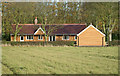
Camblesforth Quosquo Estate Shooting Box Cottage
Image: © Gordon Kneale Brooke
Taken: 16 Nov 2008
0.02 miles
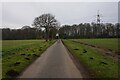
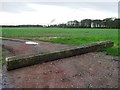
2

Lane near Shooting Box Cottage
Looking along Chester Court Road with Chester Court Wood on the left and Weddalls Plantation to the right.
Image: © DS Pugh
Taken: 27 May 2023
0.03 miles
3
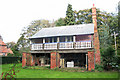
Camblesforth, QuosQuo Shooting Box
Image: © Gordon Kneale Brooke
Taken: 4 Nov 2006
0.04 miles
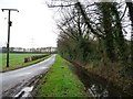
4
Chester Court Road towards Weddalls Plantation
Image: © Ian S
Taken: 22 Dec 2021
0.05 miles
5
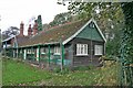
Camblesforth Quosquo Estate The Old Shooting Lodge Cottage
The cottage was demolished august 2008 to make way for the new cottage
Image: © Gordon Kneale Brooke
Taken: 4 Nov 2006
0.06 miles
6

Farmland beside Weddalls Plantation
Looking across fields of cereal crops near Shooting Box Cottage.
Image: © DS Pugh
Taken: 27 May 2023
0.09 miles
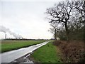
7
Blocked farm track alongside Jub Close Wood
The track leads south then west to Chestercourt Hall Farm. The plume of smoke on the horizon comes from Eggborough power station.
Image: © Christine Johnstone
Taken: 13 Jan 2016
0.15 miles
8
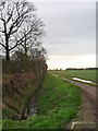
Field track and drain alongside Jub Close Wood
This area of drained flat farmland lies between the tidal rivers Aire and Ouse, and is about 5 metres above sea level.
Image: © Christine Johnstone
Taken: 13 Jan 2016
0.16 miles
9
Chester Court Road at Jub Close Wood
Heading south-east, with Drax power station on the horizon.
Image: © Christine Johnstone
Taken: 13 Jan 2016
0.17 miles
10
Full drain alongside Chester Court Road
Looking south-east from the bend at Chestercourt Hall Farm. This is an area of flat drained former common, about 5 metres above sea level, between the tidal rivers Aire and Ouse.
Image: © Christine Johnstone
Taken: 13 Jan 2016
0.17 miles