IMAGES TAKEN NEAR TO
Back Lane, THIRSK, YO7 3RY
Introduction
This page details the photographs taken nearby to Back Lane, YO7 3RY by members of the Geograph project.
The Geograph project started in 2005 with the aim of publishing, organising and preserving representative images for every square kilometre of Great Britain, Ireland and the Isle of Man.

There are currently over 7.5m images from over14,400 individuals and you can help contribute to the project by visiting https://www.geograph.org.uk
Image Map
Images are licensed for reuse under creativecommons.org/licenses/by-sa/2.0
Notes
- Clicking on the map will re-center to the selected point.
- The higher the marker number, the further away the image location is from the centre of the postcode.
Image Listing (81 Images Found)
Images are licensed for reuse under creativecommons.org/licenses/by-sa/2.0
Image
Details
Distance
1
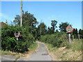
Back Lane, Topcliffe
Back Lane joins Long Street with the road to Busby Stoop and probably marks the end of former 'toft and croft' lands, where the original dwellings along what is now Front Street would have had long strips of land to the rear where small amounts of food could be grown or a few animals kept.
Image: © Gordon Hatton
Taken: 1 Jul 2018
0.04 miles
2
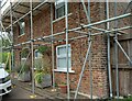
Topcliffe, 18 Long Street
This property is on the north side of Long Street in Topcliffe village. According to early OS maps there should be a benchmark on this front facing wall, to the right. There was nothing to see and conclude that the mark is likely destroyed.
Image: © Mel Towler
Taken: 31 Jul 2021
0.04 miles
3
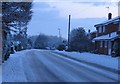
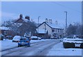
Snowy morning, Topcliffe
Tricky conditions on the A167 in Long Street Topcliffe.
Image: © Gordon Hatton
Taken: 9 Jan 2010
0.07 miles
4
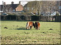
Shetland Ponies Topcliffe
A tall hedge, or small horses? The latter is correct as a local breeder keeps some very small Shetlands [and some normal sized llamas].
Image: © Gordon Hatton
Taken: 30 Jan 2007
0.07 miles
5
Snowy morning, Topcliffe
The A167 at Long Street Topcliffe on a snowy morning.
Image: © Gordon Hatton
Taken: 9 Jan 2010
0.07 miles
6

Front Street Topcliffe
The house nearest the camera was once the Golden Lion Inn and is early 18th century with side sliding ['Yorkshire light'] sash windows on the ground floor. The steep pitch of its pantiled roof suggests that it may once have been thatched.
Image: © Gordon Hatton
Taken: 30 Jan 2007
0.09 miles
7
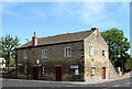
The Toll Booth
This unassuming little building is the oldest in the village and dates back to the medieval period, being part of the manor of Topcliffe. Here, the lord of the manor collected market tolls and held the court leat, which was a criminal court dealing with petty crimes such as breaches of the peace, adultery, eavesdropping and scolds, whilst it also oversaw the regulation of bread and ale.
Image: © Gordon Hatton
Taken: 1 Jul 2018
0.09 miles
8

Hall Farm, Topcliffe
Hall Farm is the name given to this substantial mid 18th century house on Front Street in Topcliffe, but it is a farmhouse no longer, having long since lost its farm buildings and land. Where there were once paddocks there is now a small housing estate.
Image: © Gordon Hatton
Taken: 18 Dec 2009
0.09 miles
9
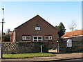
Topcliffe village hall
Village hall in the centre of the village. I wonder if there are any casualties inside left over from the Burns Night supper?
Image: © Gordon Hatton
Taken: 30 Jan 2007
0.09 miles
10
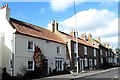
The Elm Gallery, Topcliffe
Previously photographed by me in 2009, the building in the foreground, once the village post office, is now a small art gallery and shop.
Image: © Gordon Hatton
Taken: 26 Oct 2018
0.09 miles