IMAGES TAKEN NEAR TO
Balk Top, Dishforth Airfield, THIRSK, YO7 3DD
Introduction
This page details the photographs taken nearby to Balk Top, Dishforth Airfield, YO7 3DD by members of the Geograph project.
The Geograph project started in 2005 with the aim of publishing, organising and preserving representative images for every square kilometre of Great Britain, Ireland and the Isle of Man.

There are currently over 7.5m images from over14,400 individuals and you can help contribute to the project by visiting https://www.geograph.org.uk
Image Map
Images are licensed for reuse under creativecommons.org/licenses/by-sa/2.0
Notes
- Clicking on the map will re-center to the selected point.
- The higher the marker number, the further away the image location is from the centre of the postcode.
Image Listing (9 Images Found)
Images are licensed for reuse under creativecommons.org/licenses/by-sa/2.0
Image
Details
Distance
1
Houses at Balk Top, Dishforth Airfield
Probably built for the RAF, although the airfield is now operated by the British Army.
Image: © Christine Johnstone
Taken: 26 Aug 2018
0.03 miles
2
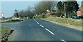
Boroughbridge road south of Dishforth Airfield
Before Dishforth Airfield was constructed due to WWII, truncating the road ahead, this was one of the two main north-south routes that converged on Boroughbridge. The housing visible to the right is clearly RAF standard issue.
Image: © Toby Speight
Taken: 23 Mar 2003
0.09 miles
3
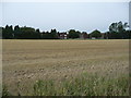
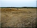
Broad Balk, harvested
A cereal field between Norton-le-Clay and Dishforth Airfield.
Image: © Christine Johnstone
Taken: 26 Aug 2018
0.10 miles
4
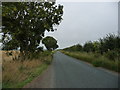
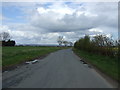
Broad Balk Lane, off Boroughbridge Road
Heading north-east towards Norton-le-Clay.
Image: © Christine Johnstone
Taken: 26 Aug 2018
0.10 miles
6
Swiss rolls, off Boroughbridge Road
Straw gathered in at the wet end of a hot, dry August.
Image: © Christine Johnstone
Taken: 26 Aug 2018
0.14 miles
8
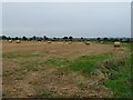
Baled straw, off Boroughbridge Road
Safely gathered in at the wet end of a hot, dry August.
Image: © Christine Johnstone
Taken: 26 Aug 2018
0.17 miles
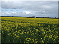
9
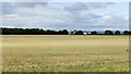
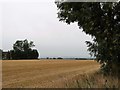
Barley field on north side of Highfields Lane
This is close to the airfield at Dishforth; it lies to the north, beyond the trees at the left side of the image.
The buildings seen between the trees are at North Hill Farm.
Image: © Trevor Littlewood
Taken: 16 Jul 2020
0.23 miles