IMAGES TAKEN NEAR TO
Sproxton, YORK, YO62 5EL
Introduction
This page details the photographs taken nearby to YO62 5EL by members of the Geograph project.
The Geograph project started in 2005 with the aim of publishing, organising and preserving representative images for every square kilometre of Great Britain, Ireland and the Isle of Man.

There are currently over 7.5m images from over14,400 individuals and you can help contribute to the project by visiting https://www.geograph.org.uk
Image Map
Images are licensed for reuse under creativecommons.org/licenses/by-sa/2.0
Notes
- Clicking on the map will re-center to the selected point.
- The higher the marker number, the further away the image location is from the centre of the postcode.
Image Listing (8 Images Found)
Images are licensed for reuse under creativecommons.org/licenses/by-sa/2.0
Image
Details
Distance
2
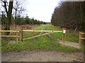
Gated track into Pry Rigg Plantation at Double Dikes
Most of the tracks into the forests in this part of North Yorkshire have been gated and locked to prevent unauthorised access.
Image: © Phil Catterall
Taken: 5 Dec 2006
0.19 miles
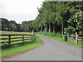
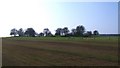
4
Country lane running past Pry Rigg Plantation
Image: © Phil Catterall
Taken: 5 Dec 2006
0.19 miles
5
The Bronze Age Studfold Ring
A Hill Fort, Iron Age, there seems to be a differing ideas among the ancient historians.
Image: © Martin Dawes
Taken: 30 Jun 2012
0.22 miles
6
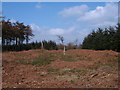
Double Dykes, Pry Rigg
Parallel banks with possibly a ditch between. This feature cuts across a broad ridge by Studford Farm and one would assume that it is a prehistoric earthwork, although I could find no reference to it on the National Monuments Record.
Image: © Gordon Hatton
Taken: 27 Mar 2011
0.23 miles
7
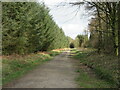
Forest track, Pry Rigg
Around 90% of this grid square is covered by Pry Rigg Plantation, although if one looks back at old maps it is apparent that much of the area was once either farmed or was moorland. Trees along the nearby road edge are mostly mature beech or younger birch, but the conifers dominate the area behind.
Image: © Gordon Hatton
Taken: 27 Mar 2021
0.23 miles
8
Studfold Ring
Seen from the east, this feature appears as a low bank with small trees on and within the earthwork. One would assume that this is a prehistoric site, but it appears to be largely medieval and would have been used as some sort of corral for horses.
Image: © Gordon Hatton
Taken: 27 Mar 2011
0.25 miles