IMAGES TAKEN NEAR TO
Hall Road, YORK, YO43 3BA
Introduction
This page details the photographs taken nearby to Hall Road, YO43 3BA by members of the Geograph project.
The Geograph project started in 2005 with the aim of publishing, organising and preserving representative images for every square kilometre of Great Britain, Ireland and the Isle of Man.

There are currently over 7.5m images from over14,400 individuals and you can help contribute to the project by visiting https://www.geograph.org.uk
Image Map
Images are licensed for reuse under creativecommons.org/licenses/by-sa/2.0
Notes
- Clicking on the map will re-center to the selected point.
- The higher the marker number, the further away the image location is from the centre of the postcode.
Image Listing (264 Images Found)
Images are licensed for reuse under creativecommons.org/licenses/by-sa/2.0
Image
Details
Distance
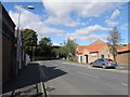
1

Railway cottages on Londesborough road, Market Weighton
Grade II listed former railway crossing-keepers' cottages.
Image: © JThomas
Taken: 18 Nov 2021
0.03 miles
2
Market Weighton railway station (site), Yorkshire
Opened in 1847 by the York and North Midland Railway, later part of the North Eastern Railway, as the terminus of the line from York. Other lines to Selby, Driffield and Beverley later made the station into a junction. Nevertheless it closed to all traffic in 1965.
View east towards Everingham and Selby, also Londesborough and York. The station site has been redeveloped for housing and little trace of a railway remains.
See http://www.disused-stations.org.uk/m/market_weighton/index.shtml for more details.
Image: © Nigel Thompson
Taken: 20 Jan 2018
0.05 miles
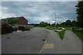
3
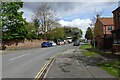
Londesborough Road
Looking along Londesborough Road in Market Weighton towards some resurfacing vehicles.
Image: © DS Pugh
Taken: 27 Apr 2024
0.06 miles
5
Wildlife area, off Londesborough Road
A disused graveyard on the north side of Market Weighton has been turned into a wildlife area. It fell out of use before 1890.
Image: © Christine Johnstone
Taken: 23 Apr 2021
0.07 miles
6
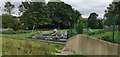
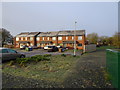
Playground on site of old railway station
Image: © Chris Morgan
Taken: 8 Sep 2020
0.07 miles
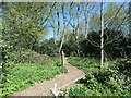
7
Hall Road
Looking towards the Market Weighton to Beverley path on the former York to Beverley railway line.
Image: © DS Pugh
Taken: 20 Jun 2020
0.08 miles
8
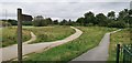
Paths across site of Market Weighton station
Where lines from Driffield and Beverley converged, going on beyond the station either to Selby or York.
Image: © Chris Morgan
Taken: 8 Sep 2020
0.08 miles
9
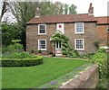
Station Farm
Built over 200 yrs ago, this former farmhouse was once owned by the Londesborough Estate, and still bears their coat of arms above the central doorway.
Image: © Mike Kirby
Taken: 30 Apr 2014
0.09 miles