IMAGES TAKEN NEAR TO
Gowthorpe Lane, YORK, YO41 5QL
Introduction
This page details the photographs taken nearby to Gowthorpe Lane, YO41 5QL by members of the Geograph project.
The Geograph project started in 2005 with the aim of publishing, organising and preserving representative images for every square kilometre of Great Britain, Ireland and the Isle of Man.

There are currently over 7.5m images from over14,400 individuals and you can help contribute to the project by visiting https://www.geograph.org.uk
Image Map
Images are licensed for reuse under creativecommons.org/licenses/by-sa/2.0
Notes
- Clicking on the map will re-center to the selected point.
- The higher the marker number, the further away the image location is from the centre of the postcode.
Image Listing (11 Images Found)
Images are licensed for reuse under creativecommons.org/licenses/by-sa/2.0
Image
Details
Distance
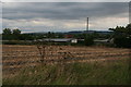
2

Towards White Hill Farm
Compare with Image taken 9 months previous.
Image: © DS Pugh
Taken: 12 Apr 2007
0.13 miles
3

Haystack - Gowthorpe
Looking towards White Hill farm.
Image: © DS Pugh
Taken: 30 Jul 2006
0.14 miles
4
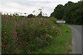
Wildflowers on the roadside, Gowthorpe
Or weeds, depending: fireweed, hogweed, meadowsweeta and meadow cranesbill.
Image: © Chris
Taken: 9 Aug 2015
0.17 miles

6
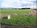
Gowthorpe Fields
Looking SE, a typical view of the farmland in this area.
Image: © Stephen Horncastle
Taken: 18 Feb 2006
0.22 miles
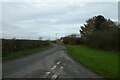
7
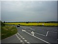
Fangfoss road
Looking along the road from Full Sutton in the direction of Fangfoss. This area is a former airfield, now an industrial estate complete with a prison..
Image: © DS Pugh
Taken: 25 May 2009
0.22 miles
8
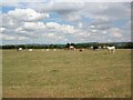
Cows near Fangfoss
Just north of Fangfoss, a herd of cows. Yorkshire Wolds behind.
Image: © DS Pugh
Taken: 30 Jul 2006
0.24 miles
9
Kirklands Lane near Tynewood Farm
Looking along the road beside Gowthorpe Farm.
Image: © DS Pugh
Taken: 26 Nov 2022
0.24 miles
10
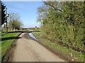
Lane out of Gowthorpe to junction with Kirklands Lane
Ditch to the right flooded and coming onto the road.
Image: © Martin Dawes
Taken: 14 Mar 2016
0.25 miles