IMAGES TAKEN NEAR TO
Storking Lane, YORK, YO41 5NF
Introduction
This page details the photographs taken nearby to Storking Lane, YO41 5NF by members of the Geograph project.
The Geograph project started in 2005 with the aim of publishing, organising and preserving representative images for every square kilometre of Great Britain, Ireland and the Isle of Man.

There are currently over 7.5m images from over14,400 individuals and you can help contribute to the project by visiting https://www.geograph.org.uk
Image Map (Loading...)


Getting Data...Please wait
Leaflet Map data © OpenStreetMap
Images are licensed for reuse under creativecommons.org/licenses/by-sa/2.0
Notes
- Clicking on the map will re-center to the selected point.
- The higher the marker number, the further away the image location is from the centre of the postcode.
Image Listing (81 Images Found)
Images are licensed for reuse under creativecommons.org/licenses/by-sa/2.0
Image
Details
Distance
1
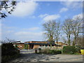
Children's Nursery, Storking Lane, Wilberfoss
Image: © JThomas
Taken: 22 Apr 2011
0.02 miles
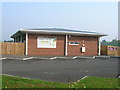
2

Kiddies Corner Day Nursery, Wilberfoss
Image: © Jonathan Thacker
Taken: 14 Apr 2018
0.03 miles
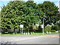
3

St Oswalds Close Wilberfoss
Taken from the Junction of Ings Road and Storking Lane facing SE this picture shows the west entrance to St Oswalds
Image: © Keith Laverack
Taken: 26 Mar 2008
0.03 miles
5
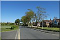
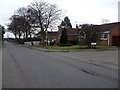
Storking Lane
Looking along the road through Wilberfoss near Ings Road.
Image: © DS Pugh
Taken: 19 Apr 2020
0.04 miles
6
Wilberfoss Church of England (Voluntary Controlled) Primary School
A medium sized primary school with about 240 pupils.
Image: © Jonathan Thacker
Taken: 14 Apr 2018
0.05 miles
7
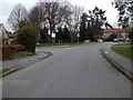
Ings Road Storking Lane Junction
Facing east the junction between Storking Lane and Ings Road is seen on the right when leaving Wilberfoss towards Fangfoss.
Image: © Keith Laverack
Taken: 26 Mar 2008
0.06 miles
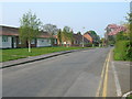
8
Storking Lane Passing Hawthorn Drive and Park Lane
Leaving the village of Wilberfoss along Storking Lane in a NNE direction the road passes Park Lane on the left and Hawthorn Drive on the right. Left at the cottages is the public footpath to High Catton and the road to the village club and playing field.
Image: © Keith Laverack
Taken: 26 Mar 2008
0.07 miles
9
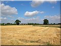
Harvested corn in Wilberfoss
On the edge of Wilberfoss a field has been harvested. This year has had one of the earliest harvests of recent times.
Image: © DS Pugh
Taken: 30 Jul 2006
0.07 miles