IMAGES TAKEN NEAR TO
Derwent Close, YORK, YO41 4AW
Introduction
This page details the photographs taken nearby to Derwent Close, YO41 4AW by members of the Geograph project.
The Geograph project started in 2005 with the aim of publishing, organising and preserving representative images for every square kilometre of Great Britain, Ireland and the Isle of Man.

There are currently over 7.5m images from over14,400 individuals and you can help contribute to the project by visiting https://www.geograph.org.uk
Image Map
Images are licensed for reuse under creativecommons.org/licenses/by-sa/2.0
Notes
- Clicking on the map will re-center to the selected point.
- The higher the marker number, the further away the image location is from the centre of the postcode.
Image Listing (13 Images Found)
Images are licensed for reuse under creativecommons.org/licenses/by-sa/2.0
Image
Details
Distance
1
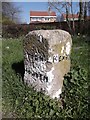
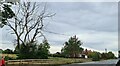
Old Guide Stone by Dauby Lane, Elvington
Guide stone by Dauby Lane to Kexby, in parish of Elvington (York District), North end of village, junction with the B1228.
Inscription reads:-
: KEXBY : : YORK / HOWDEN : : KEXBY :
Carved benchmark and rivet on top.
City of York HER.
HER Number: MYO4273 https://www.heritagegateway.org.uk/Gateway/Results_Single.aspx?uid=MYO4273&resourceID=1003
Surveyed
Milestone Society National ID: YN_XELV
Image: © Milestone Society
Taken: Unknown
0.05 miles
2
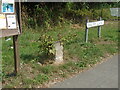
Old guidestone
On the west side of the B1228 in Elvington where Dauby Lane leads off is this stone inscribed with YORK, which is to the left, north, and HOWDEN to the right, south. On each side face hidden by the burdock plants is KEXBY. Why is Kexby on both sides? The stone was painted white with black lettering in about 2008 Image but most of it has weathered away.
Image: © Chris Minto
Taken: 14 Aug 2022
0.05 miles
3
Dauby Lane
Looking along Dauby Lane from outside the school in Elvington.
Image: © DS Pugh
Taken: 17 Apr 2017
0.06 miles
4
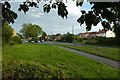
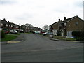
Main Street
Looking along Main Street on the outskirts of Elvington from a bench.
Image: © DS Pugh
Taken: 20 Jun 2020
0.07 miles
6
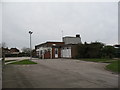
Elvington Primary School
Not a very handsome building. One of those seventies schools that is now beginning to look rather tatty.
Image: © Gordon Hatton
Taken: 4 Mar 2007
0.09 miles
8
Elvington Lane
How much longer will that tree remain standing?
Image: © Chris Morgan
Taken: 3 Oct 2022
0.11 miles
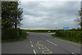
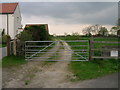
9
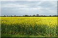
Rape field off Dauby Lane
Looking over flowering oil seed rape.
Image: © DS Pugh
Taken: 17 Apr 2017
0.13 miles
10
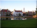
The Grey Horse
The flooding isn't putting off people from visiting the pub on a friday night! The tables outside are occupied as several children cycled through the floodwaters.
Image: © DS Pugh
Taken: 29 Jun 2007
0.19 miles