IMAGES TAKEN NEAR TO
Hutton Wandesley, YORK, YO26 7NA
Introduction
This page details the photographs taken nearby to YO26 7NA by members of the Geograph project.
The Geograph project started in 2005 with the aim of publishing, organising and preserving representative images for every square kilometre of Great Britain, Ireland and the Isle of Man.

There are currently over 7.5m images from over14,400 individuals and you can help contribute to the project by visiting https://www.geograph.org.uk
Image Map (Loading...)


Getting Data...Please wait
Leaflet Map data © OpenStreetMap
Images are licensed for reuse under creativecommons.org/licenses/by-sa/2.0
Notes
- Clicking on the map will re-center to the selected point.
- The higher the marker number, the further away the image location is from the centre of the postcode.
Image Listing (10 Images Found)
Images are licensed for reuse under creativecommons.org/licenses/by-sa/2.0
Image
Details
Distance
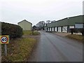
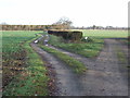
2
Industrial buildings in Hutton Wandesley
Large metal buildings on the southern side of the village.
Image: © DS Pugh
Taken: 26 Nov 2017
0.13 miles
4

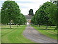
Hutton Wandesley
Long Marston church in the distance.
Image: © Nigel Thompson
Taken: 15 Dec 2013
0.18 miles
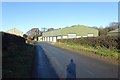
5
Spring Lane
Spring Lane approaching Hutton Wandesley
Image: © Chris Heaton
Taken: 4 Jul 2016
0.19 miles

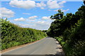
8
Field beside Hutton Street
Looking across a field in Hutton Wandesley.
Image: © DS Pugh
Taken: 13 May 2024
0.20 miles
9
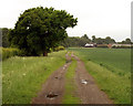
Bridleway to Hutton Wandesley
Taken on the bridleway from Rufforth to Hutton Wandesley. At the Hutton end, there's a sign, at the side of the track, that intimates that this is not a public right of way (there's no sign visible that says it is). Conversely, at the Rufforth end, there's a sign which says 'public footpath to Hutton Wandesley 1 1/4 miles'; perhaps it's only a public right of way in a westerly direction!
This square is relatively easy to access and is on public right of way, but it's the only square for miles that hasn't been 'bagged' already...... why?!
Image: © Andy Beecroft
Taken: 10 Jun 2010
0.21 miles
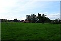
10

Hutton Wandesley
The hamlet of Hutton Wandesley is a continuation of Long Marston along the road towards Askham Richard. This field is at the centre of the settlement which comprises mostly brick built houses.
Image: © Gordon Hatton
Taken: 25 Feb 2008
0.24 miles