IMAGES TAKEN NEAR TO
Cadger Castle, DRIFFIELD, YO25 9LQ
Introduction
This page details the photographs taken nearby to Cadger Castle, YO25 9LQ by members of the Geograph project.
The Geograph project started in 2005 with the aim of publishing, organising and preserving representative images for every square kilometre of Great Britain, Ireland and the Isle of Man.

There are currently over 7.5m images from over14,400 individuals and you can help contribute to the project by visiting https://www.geograph.org.uk
Image Map
Images are licensed for reuse under creativecommons.org/licenses/by-sa/2.0
Notes
- Clicking on the map will re-center to the selected point.
- The higher the marker number, the further away the image location is from the centre of the postcode.
Image Listing (6 Images Found)
Images are licensed for reuse under creativecommons.org/licenses/by-sa/2.0
Image
Details
Distance
1
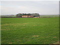
Far Falls Farm
Typical Wolds farm with a belt of trees providing some shelter on an exposed site.
Image: © Jonathan Thacker
Taken: 27 Dec 2014
0.01 miles
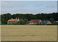
2

Far Falls Farm
View NE from the bottom SW corner of the grid square to Far Fall Farm. This is a typical view of this square.
Image: © Stephen Horncastle
Taken: 21 Jan 2006
0.06 miles
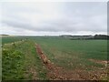
3
Farmland near Wetwang
Far Falls Farm; flat fields, far from fascinating photo.
Image: © Paul Harrop
Taken: 3 Jul 2018
0.08 miles
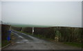
4

Across the fields to Far Falls Farm
From the lane called Cadger Castle; where they got that name from I have not a clue.
Image: © Martin Dawes
Taken: 9 Oct 2009
0.09 miles