IMAGES TAKEN NEAR TO
Middleton On The Wolds, DRIFFIELD, YO25 9DA
Introduction
This page details the photographs taken nearby to YO25 9DA by members of the Geograph project.
The Geograph project started in 2005 with the aim of publishing, organising and preserving representative images for every square kilometre of Great Britain, Ireland and the Isle of Man.

There are currently over 7.5m images from over14,400 individuals and you can help contribute to the project by visiting https://www.geograph.org.uk
Image Map
Images are licensed for reuse under creativecommons.org/licenses/by-sa/2.0
Notes
- Clicking on the map will re-center to the selected point.
- The higher the marker number, the further away the image location is from the centre of the postcode.
Image Listing (7 Images Found)
Images are licensed for reuse under creativecommons.org/licenses/by-sa/2.0
Image
Details
Distance
1
Planting potatoes
Planting potatoes on a spring evening
Image: © Ian Lavender
Taken: 10 May 2005
0.08 miles
2
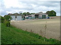
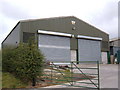
Farm Buildings near Middleton Lodge
These buildings illustrate the industrialisation of modern farming. They were built to replace buildings in the village for which plans have been made for housing.
Image: © Ian Lavender
Taken: 6 May 2005
0.08 miles
7
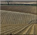
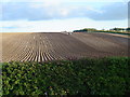
Fields on Middleton Wold
Chalky cultivated farmland on the rolling wolds landscape, south of Warter Road
Image: © Paul Harrop
Taken: 21 Apr 2013
0.23 miles